
Topografische Karte South Boston
Interaktive Karte
Klicken Sie auf die Karte, um die Höhe anzuzeigen.
Über diese Karte
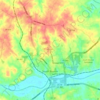
Name: Topografische Karte South Boston, Höhe, Relief.
Ort: South Boston, Halifax County, Virginia, 24592, United States (36.68532 -78.95085 36.74298 -78.86053)
Durchschnittliche Höhe: 126 m
Minimale Höhe: 94 m
Maximale Höhe: 163 m
Andere topografische Karten
Klicken Sie auf eine Karte, um ihre Topografie, ihre Höhe und ihr Relief anzuzeigen.
McKendree
United States > Virginia > Halifax County
McKendree, Halifax County, Virginia, United States
Durchschnittliche Höhe: 151 m
Sutherlin
United States > Virginia > Halifax County
Sutherlin, Halifax County, Virginia, 24594, United States
Durchschnittliche Höhe: 142 m
Nathalie
United States > Virginia > Halifax County
Nathalie, Halifax County, Virginia, 24577, United States
Durchschnittliche Höhe: 153 m
Alton
United States > Virginia > Halifax County
Alton, Halifax County, Virginia, 24520, United States
Durchschnittliche Höhe: 156 m
Clover
United States > Virginia > Halifax County
Clover, Halifax County, Virginia, 24534, United States
Durchschnittliche Höhe: 136 m