
Topografische Karte Bethelsdorp
Interaktive Karte
Klicken Sie auf die Karte, um die Höhe anzuzeigen.
Über diese Karte
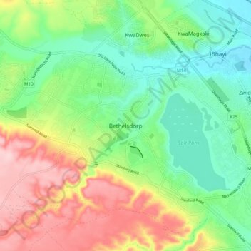
Name: Topografische Karte Bethelsdorp, Höhe, Relief.
Durchschnittliche Höhe: 85 m
Minimale Höhe: 2 m
Maximale Höhe: 217 m
Andere topografische Karten
Klicken Sie auf eine Karte, um ihre Topografie, ihre Höhe und ihr Relief anzuzeigen.
Gqeberha
South Africa > Eastern Cape > Nelson Mandela Bay Metropolitan Municipality
Gqeberha, Nelson Mandela Bay Metropolitan Municipality, Eastern Cape, 6006, South Africa
Durchschnittliche Höhe: 37 m
KwaNobuhle
South Africa > Eastern Cape > Nelson Mandela Bay Metropolitan Municipality
KwaNobuhle, Nelson Mandela Bay Metropolitan Municipality, Eastern Cape, 6242, South Africa
Durchschnittliche Höhe: 86 m
Motherwell
South Africa > Eastern Cape > Nelson Mandela Bay Metropolitan Municipality
Motherwell, Nelson Mandela Bay Metropolitan Municipality, Eastern Cape, South Africa
Durchschnittliche Höhe: 67 m
Coega
South Africa > Eastern Cape > Nelson Mandela Bay Metropolitan Municipality
Coega, Nelson Mandela Bay Ward 56, Nelson Mandela Bay Metropolitan Municipality, Eastern Cape, 6100, South Africa
Durchschnittliche Höhe: 43 m
Kariega
South Africa > Eastern Cape > Nelson Mandela Bay Metropolitan Municipality
Kariega, Nelson Mandela Bay Metropolitan Municipality, Eastern Cape, 6229, South Africa
Durchschnittliche Höhe: 89 m
Baakens River
South Africa > Eastern Cape > Nelson Mandela Bay Metropolitan Municipality > Gqeberha
Baakens River, Nelson Mandela Bay Ward 6, Gqeberha, Nelson Mandela Bay Metropolitan Municipality, Eastern Cape, 6045, South Africa
Durchschnittliche Höhe: 123 m