
Topografische Karte Wolfeboro
Interaktive Karte
Klicken Sie auf die Karte, um die Höhe anzuzeigen.
Über diese Karte
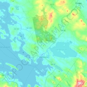
Name: Topografische Karte Wolfeboro, Höhe, Relief.
Ort: Wolfeboro, Carroll County, New Hampshire, United States (43.53895 -71.28488 43.68028 -71.05920)
Durchschnittliche Höhe: 213 m
Minimale Höhe: 149 m
Maximale Höhe: 555 m
According to the United States Census Bureau, the town has a total area of 58.5 square miles (151.4 km2), of which 48.0 square miles (124.2 km2) are land and 10.5 square miles (27.2 km2) are water, comprising 17.95% of the town. Wolfeboro is drained by the Smith River, which is the outlet of Lake Wentworth and an inlet of Lake Winnipesaukee. Via Winnipesaukee, the town is part of the Merrimack River watershed. The highest point in town is Moody Mountain, elevation 1,420 feet (430 m) above sea level, located near the northern boundary.
Andere topografische Karten
Klicken Sie auf eine Karte, um ihre Topografie, ihre Höhe und ihr Relief anzuzeigen.
Berry Bay
United States > New Hampshire > Carroll County > Freedom
Berry Bay, Freedom, Carroll County, New Hampshire, United States
Durchschnittliche Höhe: 133 m
Mount Surprise
United States > New Hampshire > Carroll County > Bartlett
Mount Surprise, Bartlett, Carroll County, New Hampshire, 03845, United States
Durchschnittliche Höhe: 284 m