Geolokalisieren

Topografische Karte Blues Point

Klicken Sie auf die Karte, um die Höhe anzuzeigen.

Über diese Karte

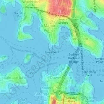
Name: Topografische Karte Blues Point, Höhe, Relief.

Ort: Blues Point, Sydney, New South Wales, 2061, Australia (-33.85064 151.20389 -33.85054 151.20399)

Durchschnittliche Höhe: 15 m

Minimale Höhe: -4 m

Maximale Höhe: 91 m

Andere topografische Karten

Klicken Sie auf eine Karte, um ihre Topografie, ihre Höhe und ihr Relief anzuzeigen.

Sydney

Australia > New South Wales > Sydney

Durchschnittliche Höhe: 23 m

Northern Beaches

Australia > New South Wales > Sydney

Durchschnittliche Höhe: 67 m

Botany Bay

Australia > New South Wales > Sydney

Durchschnittliche Höhe: 8 m

Earlwood

Australia > New South Wales > Sydney

Durchschnittliche Höhe: 23 m

Box Hill

Australia > New South Wales > Sydney

Durchschnittliche Höhe: 45 m

Macquarie Park

Australia > New South Wales > Sydney

Durchschnittliche Höhe: 59 m

Carlingford

Australia > New South Wales > Sydney

Durchschnittliche Höhe: 98 m

Marsfield

Australia > New South Wales > Sydney

Durchschnittliche Höhe: 72 m

Seaforth

Australia > New South Wales > Sydney

Durchschnittliche Höhe: 49 m

Terrey Hills

Australia > New South Wales > Sydney

Owing to its elevation and close proximity to the ocean, as well as its extensive tree canopy cover, the weather station at Terrey Hills records the mildest temperatures of any weather station in the Greater Sydney region. Under Köppen's scheme, the suburb has a borderline humid subtropical (Cfa) and oceanic…

Durchschnittliche Höhe: 146 m

Gledswood Hills

Australia > New South Wales > Sydney

Durchschnittliche Höhe: 105 m

Heathcote National Park

Australia > New South Wales > Sydney

Durchschnittliche Höhe: 178 m

Parramatta River

Australia > New South Wales > Sydney > Parramatta

Durchschnittliche Höhe: 43 m

Longneck Lagoon

Australia > New South Wales > Sydney

Durchschnittliche Höhe: 21 m

Northern Beaches Council

Australia > New South Wales > Sydney

Durchschnittliche Höhe: 67 m

Lane Cove

Australia > New South Wales > Sydney

Durchschnittliche Höhe: 52 m

Royal Botanic Garden

Australia > New South Wales > Sydney

Durchschnittliche Höhe: 16 m

Glenhaven

Australia > New South Wales > Sydney

Durchschnittliche Höhe: 132 m

Lewisham

Australia > New South Wales > Sydney

Durchschnittliche Höhe: 28 m

Revesby Flood Reserve

Australia > New South Wales > Sydney

Durchschnittliche Höhe: 22 m

Vielen Dank für die Unterstützung dieser Website ❤️
Spenden

Airds

Australia > New South Wales > Sydney

Durchschnittliche Höhe: 123 m

Lindfield

Australia > New South Wales > Sydney

Durchschnittliche Höhe: 79 m

Moore Park

Australia > New South Wales > Sydney

Durchschnittliche Höhe: 43 m

Belrose

Australia > New South Wales > Sydney

Durchschnittliche Höhe: 124 m

Lane Cove National Park

Australia > New South Wales > Sydney

The park includes areas of land which are part of Ku-ring-gai, Ryde, and Hornsby local government areas with small areas of the park in Willoughby, Lane Cove and Hunter's Hill local government areas on the banks of the lower reaches of the river. The park is surrounded on all sides by developed suburban areas…

Durchschnittliche Höhe: 81 m

Castle Hill

Australia > New South Wales > Sydney

Durchschnittliche Höhe: 123 m

Cartwright

Australia > New South Wales > Sydney

Durchschnittliche Höhe: 26 m

Hurstville

Australia > New South Wales > Sydney

Durchschnittliche Höhe: 50 m

Killara

Australia > New South Wales > Sydney

Durchschnittliche Höhe: 86 m

Ermington

Australia > New South Wales > Sydney

Durchschnittliche Höhe: 32 m

Heathcote

Australia > New South Wales > Sydney

Durchschnittliche Höhe: 148 m

Georges Hall

Australia > New South Wales > Sydney

Durchschnittliche Höhe: 17 m

Lilyfield

Australia > New South Wales > Sydney

Durchschnittliche Höhe: 18 m

Mount Kuring-Gai

Australia > New South Wales > Sydney

Mount Kuring-gai is located approximately 7 km north of Hornsby. Its neighbouring suburbs are Berowra to the north, and Mount Colah to the south. Surrounded by bushland, it is bordered by Ku-ring-gai Chase National Park on the eastern side and by Berowra Valley Regional Park on the western side. There are…

Durchschnittliche Höhe: 133 m

Castle Cove

Australia > New South Wales > Sydney

Durchschnittliche Höhe: 56 m

Roseville

Australia > New South Wales > Sydney

Durchschnittliche Höhe: 84 m

Turramurra

Australia > New South Wales > Sydney

Durchschnittliche Höhe: 143 m

Holsworthy

Australia > New South Wales > Sydney

Durchschnittliche Höhe: 121 m

Winmalee

Australia > New South Wales > Sydney

Durchschnittliche Höhe: 270 m

North Turramurra

Australia > New South Wales > Sydney

Durchschnittliche Höhe: 136 m

Cabramatta

Australia > New South Wales > Sydney

Durchschnittliche Höhe: 16 m

Centennial Park

Australia > New South Wales > Sydney

Durchschnittliche Höhe: 51 m

North Sydney

Australia > New South Wales > Sydney

Durchschnittliche Höhe: 50 m

Marrickville

Australia > New South Wales > Sydney

Durchschnittliche Höhe: 17 m

Freemans Reach

Australia > New South Wales > Sydney

Durchschnittliche Höhe: 22 m

Ku-ring-gai Chase National Park

Australia > New South Wales > Sydney

Ku-ring-gai Chase is part of the Hornsby Plateau, a massive block of sandstone tilting upwards to the north. The park comprises a plateau with an elevation of generally 150–200 m above sea level. Between 250 and 200 million years ago, sand silt and mud was deposited by rivers across flood plains. These…

Durchschnittliche Höhe: 83 m

Agnes Banks

Australia > New South Wales > Sydney

Durchschnittliche Höhe: 24 m

Long Reef

Australia > New South Wales > Sydney

Durchschnittliche Höhe: 1 m

Whale Beach

Australia > New South Wales > Sydney

Durchschnittliche Höhe: 17 m

Bondi Beach

Australia > New South Wales > Sydney

Durchschnittliche Höhe: 31 m

Curl Curl Beach

Australia > New South Wales > Sydney

Durchschnittliche Höhe: 14 m

Mount Lewis

Australia > New South Wales > Sydney

Durchschnittliche Höhe: 39 m

Scotland Island

Australia > New South Wales > Sydney

Durchschnittliche Höhe: 17 m

Woodford

Australia > New South Wales > Sydney

Woodford is a village in the Blue Mountains in New South Wales, Australia, about 90 kilometres west of Sydney. Its elevation is 609 metres (1,998 ft) above sea level. It is situated on the Great Western Highway and has a railway station (opened in 1868 as Buss's Platform) on the Main Western railway line…

Durchschnittliche Höhe: 544 m

Rockdale

Australia > New South Wales > Sydney

Durchschnittliche Höhe: 20 m

Wicks Park

Australia > New South Wales > Sydney

Durchschnittliche Höhe: 17 m

Bella Vista

Australia > New South Wales > Sydney

Durchschnittliche Höhe: 79 m

Waverton

Australia > New South Wales > Sydney

Durchschnittliche Höhe: 33 m

Berkshire Park

Australia > New South Wales > Sydney

Durchschnittliche Höhe: 27 m

St Leonards

Australia > New South Wales > Sydney

Durchschnittliche Höhe: 69 m

Meadowbank Park

Australia > New South Wales > Sydney

Durchschnittliche Höhe: 14 m

Denistone West

Australia > New South Wales > Sydney

Durchschnittliche Höhe: 55 m

Nelson

Australia > New South Wales > Sydney

Durchschnittliche Höhe: 47 m

Beaconsfield

Australia > New South Wales > Sydney

Durchschnittliche Höhe: 18 m

Vielen Dank für die Unterstützung dieser Website ❤️
Spenden

Rüste dich für dein nächstes Abenteuer:

Als Amazon-Partner verdient diese Website an qualifizierten Käufen, ohne zusätzliche Kosten für Sie.

Smithfield

Australia > New South Wales > Sydney

Established in 1836, Smithfield was the first major settlement of the Fairfield LGA. The original 1838 summary plan of Smithfield shows the suburb laid out in a grid pattern with most of the streets having the same names as they do today. Its altitude ranges from 21 to 48 m (69 to 157 ft) above sea level.…

Durchschnittliche Höhe: 33 m

Beaman Park

Australia > New South Wales > Sydney

Durchschnittliche Höhe: 23 m

Browns Waterhole

Australia > New South Wales > Sydney

Durchschnittliche Höhe: 73 m

Holroyd

Australia > New South Wales > Sydney

Durchschnittliche Höhe: 24 m

Eric Primrose Reserve

Australia > New South Wales > Sydney

Durchschnittliche Höhe: 15 m

Valley Reserve

Australia > New South Wales > Sydney > Campbelltown

Durchschnittliche Höhe: 102 m

Richmond Lowlands

Australia > New South Wales > Sydney

Durchschnittliche Höhe: 13 m

Sir Thomas Mitchell Reserve

Australia > New South Wales > Sydney

Durchschnittliche Höhe: 75 m

Oyster Bay

Australia > New South Wales > Sydney

Durchschnittliche Höhe: 25 m

Killarney Heights

Australia > New South Wales > Sydney

Durchschnittliche Höhe: 72 m

North Curl Curl

Australia > New South Wales > Sydney

Durchschnittliche Höhe: 22 m

Darlinghurst

Australia > New South Wales > Sydney

Durchschnittliche Höhe: 38 m

Sans Souci

Australia > New South Wales > Sydney

Durchschnittliche Höhe: 4 m

Mosman

Australia > New South Wales > Sydney

Durchschnittliche Höhe: 29 m

Galston

Australia > New South Wales > Sydney

Durchschnittliche Höhe: 167 m

Richmond

Australia > New South Wales > Sydney

Durchschnittliche Höhe: 18 m

Gregory Hills

Australia > New South Wales > Sydney

Gregory Hills is a suburb of Sydney in the state of New South Wales, Australia in Camden Council. The suburb was assigned on 1 August 2008. The suburb was named from the topography of the local area and from the original St Gregory's Chapel on the Marist Brothers land.

Durchschnittliche Höhe: 109 m

Oran Park

Australia > New South Wales > Sydney

Durchschnittliche Höhe: 93 m

Schofields

Australia > New South Wales > Sydney

Durchschnittliche Höhe: 32 m

Moorebank

Australia > New South Wales > Sydney

Durchschnittliche Höhe: 12 m

Greystanes

Australia > New South Wales > Sydney

Durchschnittliche Höhe: 53 m

Cammeray

Australia > New South Wales > Sydney

Prior to the 1920s, the suburb was known as Suspension Bridge reflecting the now Long Gully Bridge that joined Northbridge to Cammeray. Cammeray was slow to develop mainly due to its steep topography and remoteness from transport.

Durchschnittliche Höhe: 66 m

Bringelly

Australia > New South Wales > Sydney

Durchschnittliche Höhe: 87 m

Crows Nest

Australia > New South Wales > Sydney

Durchschnittliche Höhe: 68 m

Londonderry

Australia > New South Wales > Sydney

Durchschnittliche Höhe: 29 m

Annandale

Australia > New South Wales > Sydney

Durchschnittliche Höhe: 24 m

Randwick

Australia > New South Wales > Sydney

Durchschnittliche Höhe: 44 m

Leichhardt

Australia > New South Wales > Sydney

Durchschnittliche Höhe: 22 m

Eastwood

Australia > New South Wales > Sydney

Durchschnittliche Höhe: 80 m

North Ryde

Australia > New South Wales > Sydney

Durchschnittliche Höhe: 52 m

Rydalmere

Australia > New South Wales > Sydney

Durchschnittliche Höhe: 19 m

Liverpool

Australia > New South Wales > Sydney

Durchschnittliche Höhe: 14 m

Warragamba

Australia > New South Wales > Sydney

Durchschnittliche Höhe: 157 m

Dundas Valley

Australia > New South Wales > Sydney

Durchschnittliche Höhe: 73 m

Gladesville

Australia > New South Wales > Sydney

Durchschnittliche Höhe: 28 m

Meadowbank

Australia > New South Wales > Sydney

Durchschnittliche Höhe: 19 m

Rüste dich für dein nächstes Abenteuer:

💧Wasserfilter Outdoor - Sauberes Trinkwasser aus natürlichen Quellen
🏕️Zelte - Wetterfeste Zelte für Camping und Trekking
🧳Packtaschen - Organisation im Rucksack
🧉Isolierflasche 1 Liter - Hält Getränke im Winter warm und im Sommer kühl
🩹Erste Hilfe am Berg - Anleitungen zur Versorgung von Unfällen in der Natur

Als Amazon-Partner verdient diese Website an qualifizierten Käufen, ohne zusätzliche Kosten für Sie.