
Topografische Karte Sunset Way
Interaktive Karte
Klicken Sie auf die Karte, um die Höhe anzuzeigen.
Über diese Karte
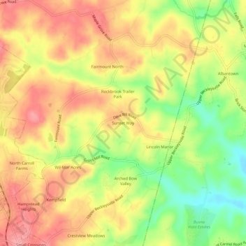
Name: Topografische Karte Sunset Way, Höhe, Relief.
Ort: Sunset Way, Carroll County, Maryland, 21074, United States (39.61288 -76.85109 39.65288 -76.81109)
Durchschnittliche Höhe: 237 m
Minimale Höhe: 180 m
Maximale Höhe: 278 m
Andere topografische Karten
Klicken Sie auf eine Karte, um ihre Topografie, ihre Höhe und ihr Relief anzuzeigen.
Gamber
United States > Maryland > Carroll County
Gamber, Carroll County, Maryland, 21048, United States
Durchschnittliche Höhe: 178 m
Clear View
United States > Maryland > Carroll County > Hampstead
Clear View, Hampstead, Carroll County, Maryland, 21074, United States
Durchschnittliche Höhe: 244 m
Sweet Air
United States > Maryland > Carroll County > Eldersburg
Sweet Air, Eldersburg, Carroll County, Maryland, 21784, United States
Durchschnittliche Höhe: 159 m
Westminster
United States > Maryland > Carroll County
Westminster, Carroll County, Maryland, United States
Durchschnittliche Höhe: 228 m
Woodbine
United States > Maryland > Carroll County > Woodbine
Woodbine, Carroll County, Maryland, 21797, United States
Durchschnittliche Höhe: 182 m