
Topografische Karte Damelevières
Interaktive Karte
Klicken Sie auf die Karte, um die Höhe anzuzeigen.
Über diese Karte
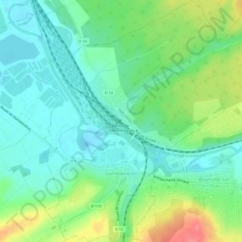
Name: Topografische Karte Damelevières, Höhe, Relief.
Durchschnittliche Höhe: 231 m
Minimale Höhe: 207 m
Maximale Höhe: 282 m
Andere topografische Karten
Klicken Sie auf eine Karte, um ihre Topografie, ihre Höhe und ihr Relief anzuzeigen.
Beuvillers
France > Grand Est > Meurthe-et-Moselle
Beuvillers, Val-de-Briey, Meurthe-et-Moselle, Grand Est, France métropolitaine, 54560, France
Durchschnittliche Höhe: 367 m
Nancy
France > Grand Est > Meurthe-et-Moselle
Nancy, Meurthe-et-Moselle, Grand Est, France métropolitaine, France
Durchschnittliche Höhe: 230 m
Chaligny
France > Grand Est > Meurthe-et-Moselle
Chaligny, Nancy, Meurthe-et-Moselle, Grand Est, France métropolitaine, 54230, France
Durchschnittliche Höhe: 333 m
Manoncourt-en-Vermois
France > Grand Est > Meurthe-et-Moselle
Manoncourt-en-Vermois, Nancy, Meurthe-et-Moselle, Grand Est, France métropolitaine, 54210, France
Durchschnittliche Höhe: 273 m
l'Avrima
France > Grand Est > Meurthe-et-Moselle > Blénod-lès-Pont-à-Mousson
l'Avrima, Blénod-lès-Pont-à-Mousson, Nancy, Meurthe-et-Moselle, Grand Est, France métropolitaine, 54700, France
Durchschnittliche Höhe: 203 m
Mercy-le-Haut
France > Grand Est > Meurthe-et-Moselle
Mercy-le-Haut, Val-de-Briey, Meurthe-et-Moselle, Grand Est, France métropolitaine, 54560, France
Durchschnittliche Höhe: 337 m
Éply
France > Grand Est > Meurthe-et-Moselle
Éply, Nancy, Meurthe-et-Moselle, Grand Est, France métropolitaine, 54610, France
Durchschnittliche Höhe: 209 m
Chambley-Bussières
France > Grand Est > Meurthe-et-Moselle
Chambley-Bussières, Toul, Meurthe-et-Moselle, Grand Est, France métropolitaine, 54890, France
Durchschnittliche Höhe: 262 m
Saint-Clément
France > Grand Est > Meurthe-et-Moselle
Saint-Clément, Lunéville, Meurthe-et-Moselle, Grand Est, France métropolitaine, 54950, France
Durchschnittliche Höhe: 259 m
Blénod-lès-Pont-à-Mousson
France > Grand Est > Meurthe-et-Moselle
Blénod-lès-Pont-à-Mousson, Nancy, Meurthe-et-Moselle, Grand Est, France métropolitaine, 54700, France
Durchschnittliche Höhe: 222 m
Varangéville
France > Grand Est > Meurthe-et-Moselle
Varangéville, Nancy, Meurthe-et-Moselle, Grand Est, France métropolitaine, 54110, France
Durchschnittliche Höhe: 240 m
Bénaménil
France > Grand Est > Meurthe-et-Moselle
Bénaménil, Lunéville, Meurthe-et-Moselle, Grand Est, France métropolitaine, 54450, France
Durchschnittliche Höhe: 260 m
Vaudémont
France > Grand Est > Meurthe-et-Moselle
Vaudémont, Nancy, Meurthe-et-Moselle, Grand Est, France métropolitaine, 54330, France
Durchschnittliche Höhe: 389 m
La Rochotte
France > Grand Est > Meurthe-et-Moselle > Pierre-la-Treiche
La Rochotte, Pierre-la-Treiche, Toul, Meurthe-et-Moselle, Grand Est, France métropolitaine, 54200, France
Durchschnittliche Höhe: 241 m
Laneuvelotte
France > Grand Est > Meurthe-et-Moselle
Laneuvelotte, Nancy, Meurthe-et-Moselle, Grand Est, France métropolitaine, 54280, France
Durchschnittliche Höhe: 245 m
Custines
France > Grand Est > Meurthe-et-Moselle
Custines, Nancy, Meurthe-et-Moselle, Grand Est, France métropolitaine, 54670, France
Durchschnittliche Höhe: 275 m
Toul
France > Grand Est > Meurthe-et-Moselle
Toul, Meurthe-et-Moselle, Grand Est, France métropolitaine, 54200, France
Durchschnittliche Höhe: 245 m
Gondrecourt-Aix
France > Grand Est > Meurthe-et-Moselle
Gondrecourt-Aix, Val-de-Briey, Meurthe-et-Moselle, Grand Est, France métropolitaine, 54800, France
Durchschnittliche Höhe: 258 m
54720
France > Grand Est > Meurthe-et-Moselle > Chenières
54720, Chenières, Val-de-Briey, Meurthe-et-Moselle, Grand Est, France métropolitaine, France
Durchschnittliche Höhe: 362 m
Herserange
France > Grand Est > Meurthe-et-Moselle
Herserange, Val-de-Briey, Meurthe-et-Moselle, Grand Est, France métropolitaine, 54440, France
Durchschnittliche Höhe: 322 m
Lac de Madine
France > Grand Est > Meurthe-et-Moselle > Pannes
Lac de Madine, Pannes, Toul, Meurthe-et-Moselle, Grand Est, France métropolitaine, 54470, France
Durchschnittliche Höhe: 228 m
Sous les Prés la Joue
France > Grand Est > Meurthe-et-Moselle > Villers-la-Montagne
Sous les Prés la Joue, Villers-la-Montagne, Val-de-Briey, Meurthe-et-Moselle, Grand Est, France métropolitaine, 54920, France
Durchschnittliche Höhe: 374 m
54400
France > Grand Est > Meurthe-et-Moselle > Cosnes-et-Romain
54400, Cosnes-et-Romain, Val-de-Briey, Meurthe-et-Moselle, Grand Est, France métropolitaine, France
Durchschnittliche Höhe: 372 m
Cosnes-et-Romain
France > Grand Est > Meurthe-et-Moselle
Cosnes-et-Romain, Val-de-Briey, Meurthe-et-Moselle, Grand Est, France métropolitaine, 54400, France
Durchschnittliche Höhe: 334 m
Maizières
France > Grand Est > Meurthe-et-Moselle
Maizières, Nancy, Meurthe-et-Moselle, Grand Est, France métropolitaine, 54550, France
Durchschnittliche Höhe: 288 m
Tellancourt
France > Grand Est > Meurthe-et-Moselle
Tellancourt, Val-de-Briey, Meurthe-et-Moselle, Grand Est, France métropolitaine, 54260, France
Durchschnittliche Höhe: 375 m
Ugny
France > Grand Est > Meurthe-et-Moselle
Ugny, Val-de-Briey, Meurthe-et-Moselle, Grand Est, France métropolitaine, 54870, France
Durchschnittliche Höhe: 306 m
Saint-Firmin
France > Grand Est > Meurthe-et-Moselle
Saint-Firmin, Nancy, Meurthe-et-Moselle, Grand Est, France métropolitaine, 54930, France
Durchschnittliche Höhe: 296 m
Deuxville
France > Grand Est > Meurthe-et-Moselle
Deuxville, Lunéville, Meurthe-et-Moselle, Grand Est, France métropolitaine, 54370, France
Durchschnittliche Höhe: 267 m
Cirey-sur-Vezouze
France > Grand Est > Meurthe-et-Moselle
Cirey-sur-Vezouze, Lunéville, Meurthe-et-Moselle, Grand Est, France métropolitaine, 54480, France
Durchschnittliche Höhe: 326 m
Allain
France > Grand Est > Meurthe-et-Moselle
Allain, Toul, Meurthe-et-Moselle, Grand Est, France métropolitaine, 54170, France
Durchschnittliche Höhe: 312 m
Sexey-aux-Forges
France > Grand Est > Meurthe-et-Moselle
Sexey-aux-Forges, Nancy, Meurthe-et-Moselle, Grand Est, France métropolitaine, 54550, France
Durchschnittliche Höhe: 309 m
Écrouves
France > Grand Est > Meurthe-et-Moselle
Écrouves, Toul, Meurthe-et-Moselle, Grand Est, France métropolitaine, 54200, France
Durchschnittliche Höhe: 271 m
Bertrichamps
France > Grand Est > Meurthe-et-Moselle
Bertrichamps, Lunéville, Meurthe-et-Moselle, Grand Est, France métropolitaine, 54120, France
Durchschnittliche Höhe: 322 m
Houdemont
France > Grand Est > Meurthe-et-Moselle
Houdemont, Nancy, Meurthe-et-Moselle, Grand Est, France métropolitaine, 54180, France
Durchschnittliche Höhe: 304 m
Vitrimont
France > Grand Est > Meurthe-et-Moselle
Vitrimont, Lunéville, Meurthe-et-Moselle, Grand Est, France métropolitaine, 54300, France
Durchschnittliche Höhe: 265 m
Mexy
France > Grand Est > Meurthe-et-Moselle
Mexy, Val-de-Briey, Meurthe-et-Moselle, Grand Est, France métropolitaine, 54135, France
Durchschnittliche Höhe: 341 m
Sexey-les-Bois
France > Grand Est > Meurthe-et-Moselle > Bois-de-Haye
Sexey-les-Bois, Bois-de-Haye, Toul, Meurthe-et-Moselle, Grand Est, France métropolitaine, 54840, France
Durchschnittliche Höhe: 260 m
Sainte-Geneviève
France > Grand Est > Meurthe-et-Moselle
Sainte-Geneviève, Nancy, Meurthe-et-Moselle, Grand Est, France métropolitaine, 54700, France
Durchschnittliche Höhe: 248 m
Bouxières-sous-Froidmont
France > Grand Est > Meurthe-et-Moselle
Bouxières-sous-Froidmont, Nancy, Meurthe-et-Moselle, Grand Est, France métropolitaine, 54700, France
Durchschnittliche Höhe: 253 m
Vandœuvre-lès-Nancy
France > Grand Est > Meurthe-et-Moselle
Vandœuvre-lès-Nancy, Nancy, Meurthe-et-Moselle, Grand Est, France métropolitaine, 54500, France
Durchschnittliche Höhe: 273 m
Pont-Saint-Vincent
France > Grand Est > Meurthe-et-Moselle
Pont-Saint-Vincent, Nancy, Meurthe-et-Moselle, Grand Est, France métropolitaine, 54550, France
Durchschnittliche Höhe: 289 m
Joudreville
France > Grand Est > Meurthe-et-Moselle
Joudreville, Val-de-Briey, Meurthe-et-Moselle, Grand Est, France métropolitaine, 54490, France
Durchschnittliche Höhe: 277 m
Sur la Route de Malleroy
France > Grand Est > Meurthe-et-Moselle > Custines
Sur la Route de Malleroy, Custines, Nancy, Meurthe-et-Moselle, Grand Est, France métropolitaine, 54670, France
Durchschnittliche Höhe: 252 m
Aboncourt
France > Grand Est > Meurthe-et-Moselle
Aboncourt, Toul, Meurthe-et-Moselle, Grand Est, France métropolitaine, 54115, France
Durchschnittliche Höhe: 373 m
Jœuf
France > Grand Est > Meurthe-et-Moselle
Jœuf, Val-de-Briey, Meurthe-et-Moselle, Grand Est, France métropolitaine, 54240, France
Durchschnittliche Höhe: 225 m
Ochey
France > Grand Est > Meurthe-et-Moselle
Ochey, Toul, Meurthe-et-Moselle, Grand Est, France métropolitaine, 54170, France
Durchschnittliche Höhe: 288 m
54115
France > Grand Est > Meurthe-et-Moselle > Vandeléville
54115, Vandeléville, Toul, Meurthe-et-Moselle, Grand Est, France métropolitaine, France
Durchschnittliche Höhe: 448 m
Jezainville
France > Grand Est > Meurthe-et-Moselle
Jezainville, Nancy, Meurthe-et-Moselle, Grand Est, France métropolitaine, 54700, France
Durchschnittliche Höhe: 239 m
Latour La Vitrée Le Saut du Cerf
France > Grand Est > Meurthe-et-Moselle > Pont-à-Mousson
Latour La Vitrée Le Saut du Cerf, Pont-à-Mousson, Nancy, Meurthe-et-Moselle, Grand Est, France métropolitaine, 54700, France
Durchschnittliche Höhe: 216 m