
Topografische Karte Salina
Interaktive Karte
Klicken Sie auf die Karte, um die Höhe anzuzeigen.
Über diese Karte
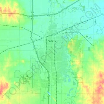
Name: Topografische Karte Salina, Höhe, Relief.
Ort: Salina, Saline County, Kansas, 67401, United States (38.75464 -97.70599 38.89597 -97.55762)
Durchschnittliche Höhe: 383 m
Minimale Höhe: 362 m
Maximale Höhe: 442 m
Salina is located at 38°50′25″N 97°36′41″W / 38.84028°N 97.61139°W / 38.84028; -97.61139 (38.8402805, -97.6114237) at an elevation of 1,224 feet (373 m). Located in North Central Kansas at the intersection of Interstate 70 and Interstate 135, it is 81 miles (130 km) north of Wichita, Kansas, 164 miles (264 km) west of Kansas City, Missouri, and 401 miles (645 km) east of Denver, Colorado.
Andere topografische Karten
Klicken Sie auf eine Karte, um ihre Topografie, ihre Höhe und ihr Relief anzuzeigen.
Gypsum
United States > Kansas > Saline County
Gypsum, Saline County, Kansas, United States
Durchschnittliche Höhe: 378 m
Saline County
United States > Kansas > Saline County
Saline County, Kansas, United States
Durchschnittliche Höhe: 406 m