
Topografische Karte Arlington
Interaktive Karte
Klicken Sie auf die Karte, um die Höhe anzuzeigen.
Über diese Karte
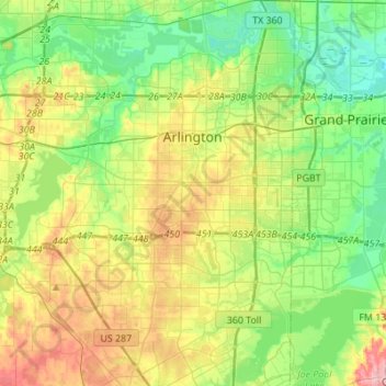
Name: Topografische Karte Arlington, Höhe, Relief.
Ort: Arlington, Tarrant County, Texas, États-Unis d'Amérique (32.58657 -97.23382 32.81712 -97.03701)
Durchschnittliche Höhe: 174 m
Minimale Höhe: 125 m
Maximale Höhe: 262 m
Andere topografische Karten
Klicken Sie auf eine Karte, um ihre Topografie, ihre Höhe und ihr Relief anzuzeigen.
Azle
États-Unis d'Amérique > Texas > Tarrant County > Azle
Azle, Tarrant County, Texas, 76020, États-Unis d'Amérique
Durchschnittliche Höhe: 224 m
Fort Worth
États-Unis d'Amérique > Texas > Tarrant County > Fort Worth
Fort Worth, Tarrant County, Texas, 76102, États-Unis d'Amérique
Durchschnittliche Höhe: 202 m