
Topografische Karte Parcou Tal Ar Vilin
Interaktive Karte
Klicken Sie auf die Karte, um die Höhe anzuzeigen.
Über diese Karte
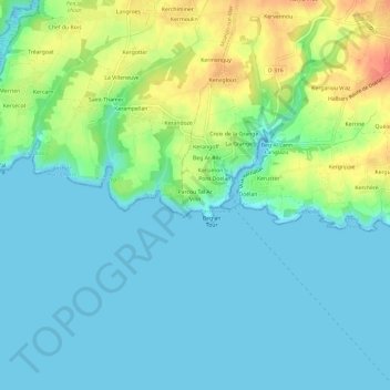
Name: Topografische Karte Parcou Tal Ar Vilin, Höhe, Relief.
Durchschnittliche Höhe: 15 m
Minimale Höhe: -5 m
Maximale Höhe: 53 m
Andere topografische Karten
Klicken Sie auf eine Karte, um ihre Topografie, ihre Höhe und ihr Relief anzuzeigen.
La Laïta
France > Bretagne > Finistère > Clohars-Carnoët
La Laïta, Clohars-Carnoët, Quimper, Finistère, Bretagne, France métropolitaine, 29360, France
Durchschnittliche Höhe: 45 m
Doelan
France > Bretagne > Finistère > Clohars-Carnoët
Doelan, Clohars-Carnoët, Quimper, Finistère, Bretagne, France métropolitaine, 29360, France
Durchschnittliche Höhe: 17 m
Rozembellec
France > Bretagne > Finistère > Clohars-Carnoët
Rozembellec, Clohars-Carnoët, Quimper, Finistère, Bretagne, France métropolitaine, 29360, France
Durchschnittliche Höhe: 50 m
Pont Doelan
France > Bretagne > Finistère > Clohars-Carnoët > Pont Doelan
Pont Doelan, Clohars-Carnoët, Quimper, Finistère, Bretagne, France métropolitaine, 29360, France
Durchschnittliche Höhe: 18 m
Menhir de l'Eglise
France > Bretagne > Finistère > Clohars-Carnoët > Rozembellec
Menhir de l'Eglise, Chemin du Presbytère, Keranguen, Rozembellec, Clohars-Carnoët, Quimper, Finistère, Bretagne, France métropolitaine, 29360, France
Durchschnittliche Höhe: 52 m
Keruster
France > Bretagne > Finistère > Clohars-Carnoët
Keruster, Clohars-Carnoët, Quimper, Finistère, Bretagne, France métropolitaine, 29360, France
Durchschnittliche Höhe: 19 m
Petit Lety
France > Bretagne > Finistère > Clohars-Carnoët
Petit Lety, Clohars-Carnoët, Quimper, Finistère, Bretagne, France métropolitaine, 29360, France
Durchschnittliche Höhe: 50 m
Lannevain
France > Bretagne > Finistère > Clohars-Carnoët
Lannevain, Clohars-Carnoët, Quimper, Finistère, Bretagne, France métropolitaine, 29360, France
Durchschnittliche Höhe: 47 m
Kergantine
France > Bretagne > Finistère > Clohars-Carnoët
Kergantine, Clohars-Carnoët, Quimper, Finistère, Bretagne, France métropolitaine, 29360, France
Durchschnittliche Höhe: 24 m