
Topografische Karte Taunton
Interaktive Karte
Klicken Sie auf die Karte, um die Höhe anzuzeigen.
Über diese Karte
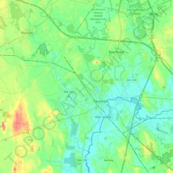
Name: Topografische Karte Taunton, Höhe, Relief.
Ort: Taunton, Bristol County, Massachusetts, United States (41.83849 -71.19390 41.99318 -70.97372)
Durchschnittliche Höhe: 22 m
Minimale Höhe: 0 m
Maximale Höhe: 78 m
Taunton has one major river, the Taunton River, along with its tributaries including the Mill River and the Three Mile River. The highest point in the city is near its southwest corner, with an elevation of 207 feet (63 m) above sea level. Prospect Hill, rising over Lake Sabbatia north of the downtown, has an elevation of 197 feet (60 m).