
Topografische Karte Stonyford
Interaktive Karte
Klicken Sie auf die Karte, um die Höhe anzuzeigen.
Über diese Karte
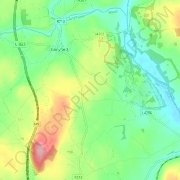
Name: Topografische Karte Stonyford, Höhe, Relief.
Durchschnittliche Höhe: 64 m
Minimale Höhe: 16 m
Maximale Höhe: 154 m
Andere topografische Karten
Klicken Sie auf eine Karte, um ihre Topografie, ihre Höhe und ihr Relief anzuzeigen.
The Municipal District of Callan — Thomastown
The Municipal District of Callan — Thomastown, County Kilkenny, Leinster, Ireland
Durchschnittliche Höhe: 100 m
Killeens
Killeens, Coolhill, The Municipal District of Callan — Thomastown, County Kilkenny, Leinster, Ireland
Durchschnittliche Höhe: 63 m
Urlingford
Urlingford, The Municipal District of Castlecomer, County Kilkenny, Leinster, Ireland
Durchschnittliche Höhe: 125 m
Westmoreland
Westmoreland, Aghaviller, The Municipal District of Callan — Thomastown, County Kilkenny, Leinster, Ireland
Durchschnittliche Höhe: 134 m
Sheastown
Sheastown, Outrath, The Municipal District of Callan — Thomastown, County Kilkenny, Leinster, Ireland
Durchschnittliche Höhe: 57 m
Kilkenny
Kilkenny, County Kilkenny, Leinster, Ireland
Durchschnittliche Höhe: 62 m