
Topografische Karte Nové Zámky
Interaktive Karte
Klicken Sie auf die Karte, um die Höhe anzuzeigen.
Über diese Karte
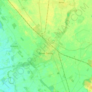
Name: Topografische Karte Nové Zámky, Höhe, Relief.
Durchschnittliche Höhe: 116 m
Minimale Höhe: 108 m
Maximale Höhe: 126 m
The town is located on the Danubian Lowland, on the Nitra River, at an altitude of 119 metres. It is located around 100 km from Bratislava and around 25 km from the Hungarian border. It is a road and railway hub of southern Slovakia.
Andere topografische Karten
Klicken Sie auf eine Karte, um ihre Topografie, ihre Höhe und ihr Relief anzuzeigen.
Rastislavice
Slovakia > Region of Nitra > District of Nové Zámky
Rastislavice, District of Nové Zámky, Region of Nitra, Western Slovakia, 941 08, Slovakia
Durchschnittliche Höhe: 125 m
Strekov
Slovakia > Region of Nitra > District of Nové Zámky
Strekov, District of Nové Zámky, Region of Nitra, Western Slovakia, 941 37, Slovakia
Durchschnittliche Höhe: 163 m
Štúrovo
Slovakia > Region of Nitra > District of Nové Zámky
Štúrovo, District of Nové Zámky, Region of Nitra, Western Slovakia, Slovakia
Durchschnittliche Höhe: 115 m