
Spenden
Rüste dich für dein nächstes Abenteuer:
Als Amazon-Partner verdient diese Website an qualifizierten Käufen, ohne zusätzliche Kosten für Sie.
Topografische Karte Weets Hill
Klicken Sie auf die Karte, um die Höhe anzuzeigen.
Spenden
Rüste dich für dein nächstes Abenteuer:
Als Amazon-Partner verdient diese Website an qualifizierten Käufen, ohne zusätzliche Kosten für Sie.
Über diese Karte
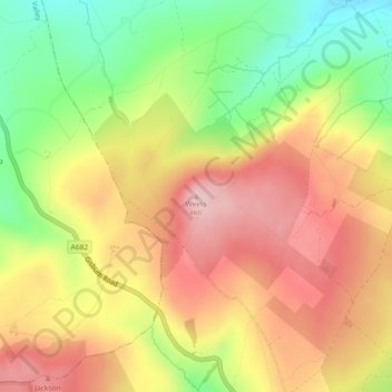
Name: Topografische Karte Weets Hill, Höhe, Relief.
Durchschnittliche Höhe: 300 m
Minimale Höhe: 187 m
Maximale Höhe: 396 m
Spenden
Rüste dich für dein nächstes Abenteuer:
Als Amazon-Partner verdient diese Website an qualifizierten Käufen, ohne zusätzliche Kosten für Sie.
Andere topografische Karten
Klicken Sie auf eine Karte, um ihre Topografie, ihre Höhe und ihr Relief anzuzeigen.
Colne Water
United Kingdom > England > Lancashire > Borough of Pendle > Laneshaw Bridge
Durchschnittliche Höhe: 202 m
Laneshaw Bridge
United Kingdom > England > Lancashire > Borough of Pendle > Laneshaw Bridge
Durchschnittliche Höhe: 269 m
Spenden
Rüste dich für dein nächstes Abenteuer:
Als Amazon-Partner verdient diese Website an qualifizierten Käufen, ohne zusätzliche Kosten für Sie.
Barnoldswick
United Kingdom > England > Lancashire > Borough of Pendle > Salterforth
Durchschnittliche Höhe: 175 m
Colne
United Kingdom > England > Lancashire > Borough of Pendle
Pendle Leisure Trust runs the Pendle Leisure Centre next to the railway station. The facility has two swimming pools, a fitness centre and gymnasium, sauna and sports hall. In summer 2013, the outdoor all-weather pitch was replaced by Urban Altitude. This outdoor aerial assault course is the first of its kind…
Durchschnittliche Höhe: 197 m
Barrowford
United Kingdom > England > Lancashire > Borough of Pendle > Barrowford
Durchschnittliche Höhe: 161 m
Spenden
Rüste dich für dein nächstes Abenteuer:
Als Amazon-Partner verdient diese Website an qualifizierten Käufen, ohne zusätzliche Kosten für Sie.
Colne
United Kingdom > England > Lancashire > Borough of Pendle
Pendle Leisure Trust runs the Pendle Leisure Centre next to the railway station. The facility has two swimming pools, a fitness centre and gymnasium, sauna and sports hall. In summer 2013, the outdoor all-weather pitch was replaced by Urban Altitude. This outdoor aerial assault course is the first of its kind…
Durchschnittliche Höhe: 197 m
Barnoldswick
United Kingdom > England > Lancashire > Borough of Pendle > Salterforth
Durchschnittliche Höhe: 175 m