
Topografische Karte Sedona
Interaktive Karte
Klicken Sie auf die Karte, um die Höhe anzuzeigen.
Über diese Karte
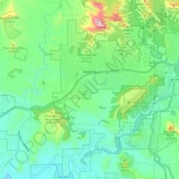
Name: Topografische Karte Sedona, Höhe, Relief.
Ort: Sedona, Sedona City Limit, Arizona, 86336, United States (34.81807 -111.84819 34.89021 -111.74289)
Durchschnittliche Höhe: 1.342 m
Minimale Höhe: 1.141 m
Maximale Höhe: 1.930 m
Sedona interior chaparral has many shrubs and small tree species of Quercus turbinella and Rhus ovata and a large population of Quercus palmeri. The Great Basin woodland has many small to medium trees of Pinus monophylla Var. fallax, Juniperus arizonica, Juniperus deppeana, Juniperus osteosperma, and Juniperus monosperma and a large population of Cupressus glabra. At higher elevations in Oak Creek Canyon Juniperus virginiana, Pinus edulis and other pines occur.[16][17]