
Topografische Karte Roxboro
Interaktive Karte
Klicken Sie auf die Karte, um die Höhe anzuzeigen.
Roxboro
Roxboro receives an average of 7.2 in (183 mm) of snow per winter. Freezing rain and sleet occur most winters, and occasionally the area experiences a major, damaging ice storm. Roxboro is often dubbed the "Snow Capital of the Triangle" because it often receives the most or close to the most snow during snowstorms in central North Carolina due to its high elevation.
Über diese Karte
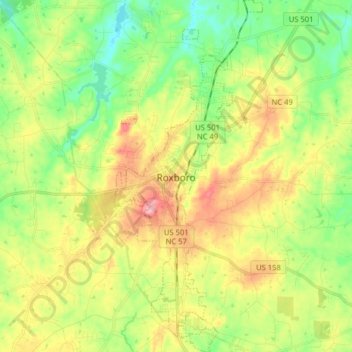
Name: Topografische Karte Roxboro, Höhe, Relief.
Ort: Roxboro, Person County, North Carolina, United States (36.33009 -79.01072 36.45819 -78.94375)
Durchschnittliche Höhe: 191 m
Minimale Höhe: 134 m
Maximale Höhe: 270 m
Andere topografische Karten
Klicken Sie auf eine Karte, um ihre Topografie, ihre Höhe und ihr Relief anzuzeigen.