

Topografische Karte Asientos
Klicken Sie auf die Karte, um die Höhe anzuzeigen.
Asientos
The municipality of Asientos is located in the north-east of the state and has a territorial area of 547.74 kilometres squared which is equivalent to 9.84% of the total area of the state and it has an altitude ranging from 1800 to 2700 metres above sea level.
Über diese Karte
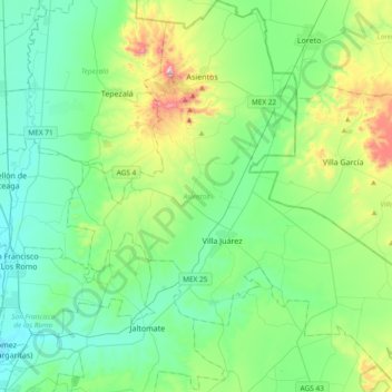
Name: Topografische Karte Asientos, Höhe, Relief.
Ort: Asientos, Aguascalientes, Mexico (21.95839 -102.21933 22.30607 -101.85416)
Durchschnittliche Höhe: 2.042 m
Minimale Höhe: 1.871 m
Maximale Höhe: 2.633 m
Andere topografische Karten
Klicken Sie auf eine Karte, um ihre Topografie, ihre Höhe und ihr Relief anzuzeigen.

Aguascalientes City
Mexico > Aguascalientes > Municipio de Aguascalientes
The Aguascalientes Bicentenary Velodrome, designed by Peter Junek, hosted the 2010 Pan American Track Championships. At an elevation of 1887m, the Velodrome is a frequent location for attempts at breaking the Cycling Hour Record.
Durchschnittliche Höhe: 1.956 m
Aguascalientes City
Mexico > Aguascalientes > Municipio de Aguascalientes
The Aguascalientes Bicentenary Velodrome, designed by Peter Junek, hosted the 2010 Pan American Track Championships. At an elevation of 1887m, the Velodrome is a frequent location for attempts at breaking the Cycling Hour Record.
Durchschnittliche Höhe: 1.956 m
Aguascalientes City
Mexico > Aguascalientes > Municipio de Aguascalientes
The Aguascalientes Bicentenary Velodrome, designed by Peter Junek, hosted the 2010 Pan American Track Championships. At an elevation of 1887m, the Velodrome is a frequent location for attempts at breaking the Cycling Hour Record.
Durchschnittliche Höhe: 1.956 m
Aguascalientes City
Mexico > Aguascalientes > Municipio de Aguascalientes
The Aguascalientes Bicentenary Velodrome, designed by Peter Junek, hosted the 2010 Pan American Track Championships. At an elevation of 1887m, the Velodrome is a frequent location for attempts at breaking the Cycling Hour Record.
Durchschnittliche Höhe: 1.956 m
San Francisco de Los Romo
Mexico > Aguascalientes > San Francisco de los Romo
Durchschnittliche Höhe: 1.909 m
Aguascalientes City
Mexico > Aguascalientes > Municipio de Aguascalientes
The Aguascalientes Bicentenary Velodrome, designed by Peter Junek, hosted the 2010 Pan American Track Championships. At an elevation of 1887m, the Velodrome is a frequent location for attempts at breaking the Cycling Hour Record.
Durchschnittliche Höhe: 1.956 m
Aguascalientes City
Mexico > Aguascalientes > Municipio de Aguascalientes
The Aguascalientes Bicentenary Velodrome, designed by Peter Junek, hosted the 2010 Pan American Track Championships. At an Elevation of 1887m, the Velodrome is a frequent location for attempts at breaking the Cycling Hour Record
Durchschnittliche Höhe: 1.956 m
