
Spenden
Rüste dich für dein nächstes Abenteuer:
Als Amazon-Partner verdient diese Website an qualifizierten Käufen, ohne zusätzliche Kosten für Sie.
Topografische Karte Isla Vista
Klicken Sie auf die Karte, um die Höhe anzuzeigen.
Spenden
Rüste dich für dein nächstes Abenteuer:
Als Amazon-Partner verdient diese Website an qualifizierten Käufen, ohne zusätzliche Kosten für Sie.
Isla Vista
Isla Vista (Spanish for "View Island") is an unincorporated community and census-designated place (CDP) in Santa Barbara County, California in the United States. As of 2020 census, the community had a population of 15,500. The majority of residents are college students at the University of California, Santa Barbara or at Santa Barbara City College. The beachside community of Isla Vista lies on a flat plateau about 30 feet (9 m) in elevation, separated from the beach by a bluff.
Spenden
Rüste dich für dein nächstes Abenteuer:
Als Amazon-Partner verdient diese Website an qualifizierten Käufen, ohne zusätzliche Kosten für Sie.
Über diese Karte
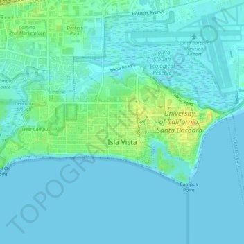
Name: Topografische Karte Isla Vista, Höhe, Relief.
Durchschnittliche Höhe: 6 m
Minimale Höhe: -2 m
Maximale Höhe: 27 m
Spenden
Rüste dich für dein nächstes Abenteuer:
Als Amazon-Partner verdient diese Website an qualifizierten Käufen, ohne zusätzliche Kosten für Sie.
Andere topografische Karten
Klicken Sie auf eine Karte, um ihre Topografie, ihre Höhe und ihr Relief anzuzeigen.
Spenden
Rüste dich für dein nächstes Abenteuer:
Als Amazon-Partner verdient diese Website an qualifizierten Käufen, ohne zusätzliche Kosten für Sie.
Vandenberg Village
United States > California > Santa Barbara County > Lompoc
Durchschnittliche Höhe: 132 m
Spenden
Rüste dich für dein nächstes Abenteuer:
Als Amazon-Partner verdient diese Website an qualifizierten Käufen, ohne zusätzliche Kosten für Sie.
Shoreline Park
United States > California > Santa Barbara County > Santa Barbara
Durchschnittliche Höhe: 21 m
West Beach
United States > California > Santa Barbara County > Santa Barbara
Durchschnittliche Höhe: 8 m
Spenden
Rüste dich für dein nächstes Abenteuer:
Als Amazon-Partner verdient diese Website an qualifizierten Käufen, ohne zusätzliche Kosten für Sie.
Jalama Beach County Park
United States > California > Santa Barbara County > Jalama
Durchschnittliche Höhe: 40 m
North Santa Maria
United States > California > Santa Barbara County > Santa Maria
Durchschnittliche Höhe: 65 m
Spenden
Rüste dich für dein nächstes Abenteuer:
Als Amazon-Partner verdient diese Website an qualifizierten Käufen, ohne zusätzliche Kosten für Sie.
Haskell's Beach
United States > California > Santa Barbara County > Goleta
Durchschnittliche Höhe: 15 m
Spenden
Rüste dich für dein nächstes Abenteuer:
Als Amazon-Partner verdient diese Website an qualifizierten Käufen, ohne zusätzliche Kosten für Sie.
Toro Canyon
United States > California > Santa Barbara County > Toro Canyon
Durchschnittliche Höhe: 83 m
Spenden
Rüste dich für dein nächstes Abenteuer:
Als Amazon-Partner verdient diese Website an qualifizierten Käufen, ohne zusätzliche Kosten für Sie.
Santa Maria
United States > California > Santa Barbara County > Santa Maria
Durchschnittliche Höhe: 185 m
Las Positas Meadows
United States > California > Santa Barbara County > Santa Barbara
Durchschnittliche Höhe: 66 m