
Topografische Karte Picton
Interaktive Karte
Klicken Sie auf die Karte, um die Höhe anzuzeigen.
Picton
On the land side, Picton is surrounded by hills and mountains, including Te Tara-o-Te-Marama/Mount Freeth to the west, the Robertson Range to the south and Mount McCormick to the east. The Elevation Saddle connects southwest of the town with the Tuamarina River valley and contains the main land transport routes between Picton and the rest of the South Island.
Über diese Karte
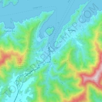
Name: Topografische Karte Picton, Höhe, Relief.
Durchschnittliche Höhe: 193 m
Minimale Höhe: -1 m
Maximale Höhe: 951 m
Andere topografische Karten
Klicken Sie auf eine Karte, um ihre Topografie, ihre Höhe und ihr Relief anzuzeigen.
Saint Arnaud Range
New Zealand > Marlborough > Marlborough District
The lower elevations are covered primarily in beech forests, while higher elevations (above about 5,000 feet) are alpine.
Durchschnittliche Höhe: 1.249 m