
Topografische Karte Sand Hill
Interaktive Karte
Klicken Sie auf die Karte, um die Höhe anzuzeigen.
Über diese Karte
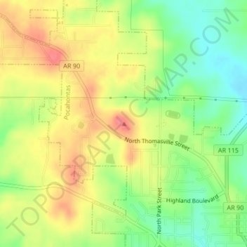
Name: Topografische Karte Sand Hill, Höhe, Relief.
Durchschnittliche Höhe: 118 m
Minimale Höhe: 84 m
Maximale Höhe: 150 m
Andere topografische Karten
Klicken Sie auf eine Karte, um ihre Topografie, ihre Höhe und ihr Relief anzuzeigen.
Pocahontas
United States > Arkansas > Randolph County > Pocahontas
Pocahontas, Randolph County, Arkansas, United States
Durchschnittliche Höhe: 96 m
Pocahontas
United States > Arkansas > Randolph County > Pocahontas
Pocahontas, Randolph County, Arkansas, 72455, United States
Durchschnittliche Höhe: 94 m