
Topografische Karte Glen Coe
Interaktive Karte
Klicken Sie auf die Karte, um die Höhe anzuzeigen.
Über diese Karte
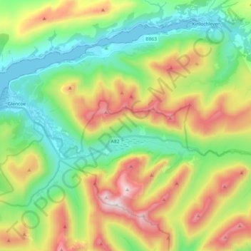
Name: Topografische Karte Glen Coe, Höhe, Relief.
Ort: Glen Coe, Glencoe, Highland, Scotland, United Kingdom (56.66194 -5.10835 56.68592 -4.92748)
Durchschnittliche Höhe: 414 m
Minimale Höhe: -1 m
Maximale Höhe: 1.139 m
Habitats within Glen Coe include birch woodland, moorland and peatbogs. The upland parts of the glen are one of the best habitats for alpine and sub-alpine plants in Lochaber, due to the underlying geology and range of altitude. Typical plants found on the highest slopes of the glen include lady's mantle,Sibbaldia procumbens and areas of willow scrub and Racomitrium lanuginosum moss-heath. In the lower areas of the glen bog myrtle, cotton grass, butterwort, sundew and bladderwort are to be found. There are areas of wet woodland on the floor of the glen: the woodlands are composed of alder and ash, and also provide a habitat for ground plants such as tufted hair-grass and marsh hawk's-beard. Glen Coe hosts several nationally scarce species of liverworts and mosses.