
Topografische Karte Tapia de Casariego
Interaktive Karte
Klicken Sie auf die Karte, um die Höhe anzuzeigen.
Über diese Karte
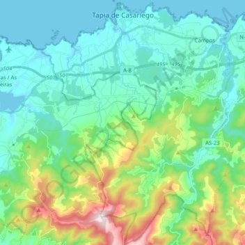
Name: Topografische Karte Tapia de Casariego, Höhe, Relief.
Ort: Tapia de Casariego, Asturias, Spain (43.46246 -6.99558 43.57613 -6.87261)
Durchschnittliche Höhe: 147 m
Minimale Höhe: -2 m
Maximale Höhe: 638 m
The council is divided into parishes, formed in turn by places or neighborhoods (small groups of widely scattered houses) throughout the territory. This is due to land ownership typical in the Autonomous Community: smallholder highly fragmented into small parcels. The terrain is gentle enough altitudes into the interior of the municipality are the most noteworthy pointing the Grandela (348 m) and the hill of Posadoiro (600 m). The Council has diverse beaches among which are found, the Penarronda (shared with the council in Castropol), Santa Gadea, Serantes, Los Campos, Porcía (Shared with the council of El Franco).
Andere topografische Karten
Klicken Sie auf eine Karte, um ihre Topografie, ihre Höhe und ihr Relief anzuzeigen.
La Barganiza
La Barganiza, Siero, Asturias, 33423, Spain
Durchschnittliche Höhe: 199 m
Peñamellera Alta
Peñamellera Alta, Asturias, 33578, Spain
Durchschnittliche Höhe: 661 m
Chagos
Spain > Asturias > Cangas del Narcea > Ḷḷarón > La Vilieḷḷa
Chagos, La Vilieḷḷa, Ḷḷarón, Cangas del Narcea, Asturias, 33811, Spain
Durchschnittliche Höhe: 958 m
Cuadonga / Covadonga
Spain > Asturias > Cangas de Onís
Cuadonga / Covadonga, Cangas de Onís, Asturias, 33589, Spain
Durchschnittliche Höhe: 504 m
Avín
Spain > Asturias > Onís > Benia de Onís
Avín, Benia de Onís, Onís, Asturias, 33556, Spain
Durchschnittliche Höhe: 393 m
Sotrondio
Spain > Asturias > Samartín del Rei Aurelio
Sotrondio, Samartín del Rei Aurelio, Asturias, 33960, Spain
Durchschnittliche Höhe: 424 m
Siecha
Spain > Asturias > Cangas del Narcea
Siecha, Cangas del Narcea, Asturias, Spain
Durchschnittliche Höhe: 892 m
Arriondas / Les Arriondes
Spain > Asturias > Parres > Arriondas / Les Arriondes
Arriondas / Les Arriondes, Parres, Asturias, 33540, Spain
Durchschnittliche Höhe: 187 m
Puertas de Vidiago
Spain > Asturias > Llanes > Puertas de Vidiago
Puertas de Vidiago, Llanes, Asturias, 33596, Spain
Durchschnittliche Höhe: 59 m
Bulnes de Arriba (El Castillo)
Spain > Asturias > Cabrales > Bulnes de Arriba (El Castillo)
Bulnes de Arriba (El Castillo), Cabrales, Asturias, 33554, Spain
Durchschnittliche Höhe: 1.138 m
Oviedo/Uviéu
Spain > Asturias > Oviedo/Uviéu
Oviedo/Uviéu, Oviedo, Asturias, 33009, Spain
Durchschnittliche Höhe: 344 m
Villanueva de Oscos
Spain > Asturias > Villanueva de Oscos > Villanueva de Oscos
Villanueva de Oscos, Asturias, 33776, Spain
Durchschnittliche Höhe: 735 m
Sobrescobio
Spain > Asturias > Sobrescobio
Sobrescobio, Asturias, 33993, Spain
Durchschnittliche Höhe: 833 m
Fuso de la Reina
Spain > Asturias > Fuso de la Reina
Fuso de la Reina, Asturias, 33140, Spain
Durchschnittliche Höhe: 240 m
Distrito Sur
Distrito Sur, Gijón, Asturias, Spain
Durchschnittliche Höhe: 28 m