
Topografische Karte Falls Creek
Interaktive Karte
Klicken Sie auf die Karte, um die Höhe anzuzeigen.
Über diese Karte
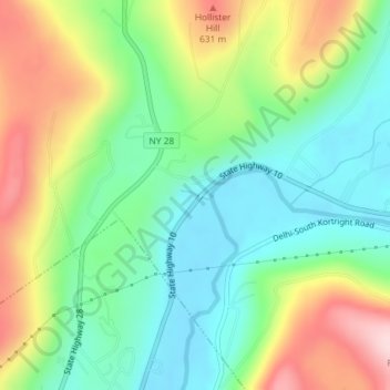
Name: Topografische Karte Falls Creek, Höhe, Relief.
Durchschnittliche Höhe: 515 m
Minimale Höhe: 414 m
Maximale Höhe: 686 m
Andere topografische Karten
Klicken Sie auf eine Karte, um ihre Topografie, ihre Höhe und ihr Relief anzuzeigen.
Long Island
Long Island, Ronkonkoma, Suffolk County, New York, USA
Durchschnittliche Höhe: 43 m
Staten Island
Staten Island, Richmond County, New York, USA
Durchschnittliche Höhe: 11 m
Homestead Park
USA > New York > Homestead Park
Homestead Park, Westchester County, New York, 10801, USA
Durchschnittliche Höhe: 17 m
Roosevelt Island
Roosevelt Island, Manhattan Community Board 8, New York County, New York, 10044, USA
Durchschnittliche Höhe: 13 m
Twin Mountains
Twin Mountains, Franklin County, New York, USA
Durchschnittliche Höhe: 553 m
Flat Top Mountain
Flat Top Mountain, Franklin County, New York, USA
Durchschnittliche Höhe: 568 m
Cooper's Cave
USA > New York > Village of South Glens Falls
Cooper's Cave, Coopers Cave Bridge, Village of South Glens Falls, Moreau, Saratoga County, New York, 12801, USA
Durchschnittliche Höhe: 98 m
Crows Nest
Crows Nest, Saint Lawrence County, New York, USA
Durchschnittliche Höhe: 114 m
Escarpment
USA > New York > Escarpment
Escarpment, Lewiston Town, Niagara County, New York, 14092, USA
Durchschnittliche Höhe: 156 m
Jordan River
Jordan River, Saint Lawrence County, New York, USA
Durchschnittliche Höhe: 479 m
Big Bear Mountain
Big Bear Mountain, Town of Johnsburg, Warren County, New York, USA
Durchschnittliche Höhe: 616 m
Boundary Peak
Boundary Peak, Essex County, New York, USA
Durchschnittliche Höhe: 1.175 m
South Glens Falls
USA > New York > South Glens Falls
South Glens Falls, Moreau, Saratoga County, New York, 12803, USA
Durchschnittliche Höhe: 97 m
Ebenezer
USA > New York > West Seneca > Ebenezer
Ebenezer, West Seneca, Erie County, New York, 14224, USA
Durchschnittliche Höhe: 201 m
Niagara Falls
USA > New York > Niagara Falls
Niagara Falls, Niagara County, New York, USA
Durchschnittliche Höhe: 180 m