
Topografische Karte Huntley
Interaktive Karte
Klicken Sie auf die Karte, um die Höhe anzuzeigen.
Über diese Karte
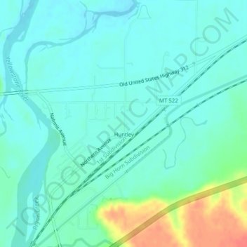
Name: Topografische Karte Huntley, Höhe, Relief.
Ort: Huntley, Yellowstone County, Montana, United States (45.88711 -108.31916 45.91403 -108.29097)
Durchschnittliche Höhe: 924 m
Minimale Höhe: 911 m
Maximale Höhe: 965 m
During the Yellowstone Flood of 1937, the damage to Huntley was more extensive, percentage-wise, than in any other community in the region. Much of the original town of Huntley was destroyed and significant portions of the land it occupied was claimed or compromised by the Yellowstone River. The flood damage included washing away the suspension bridge that allowed adjacent Highway 312 to cross the river. After the flood, the site of the town was relocated from the north side of the river to the higher elevation on the south bank.
Andere topografische Karten
Klicken Sie auf eine Karte, um ihre Topografie, ihre Höhe und ihr Relief anzuzeigen.
Billings
United States > Montana > Yellowstone County
Billings, Yellowstone County, Montana, United States
Durchschnittliche Höhe: 1.023 m
Laurel
United States > Montana > Yellowstone County
Laurel, Yellowstone County, Montana, United States
Durchschnittliche Höhe: 1.019 m
Yegen
United States > Montana > Yellowstone County
Yegen, Yellowstone County, Montana, United States
Durchschnittliche Höhe: 981 m