
Spenden
Rüste dich für dein nächstes Abenteuer:
Als Amazon-Partner verdient diese Website an qualifizierten Käufen, ohne zusätzliche Kosten für Sie.
Topografische Karte Cochrane
Klicken Sie auf die Karte, um die Höhe anzuzeigen.
Spenden
Rüste dich für dein nächstes Abenteuer:
Als Amazon-Partner verdient diese Website an qualifizierten Käufen, ohne zusätzliche Kosten für Sie.
Cochrane
Until 1977, Timmins was used as the source for all weather readings attributed to Cochrane except for exceptional extremes, due to the overall similar climate due to proximity and topography. However, in December 1977, Cochrane temperature readings began to be taken from downtown after a noticeable difference in temperature was recorded two years prior in January 1976. However, to this day, if Cochrane's weather equipment fails at any time, the Timmins temperature readings are used due to the overall similarity.
Spenden
Rüste dich für dein nächstes Abenteuer:
Als Amazon-Partner verdient diese Website an qualifizierten Käufen, ohne zusätzliche Kosten für Sie.
Über diese Karte
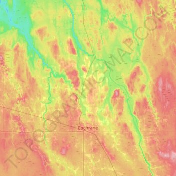
Name: Topografische Karte Cochrane, Höhe, Relief.
Durchschnittliche Höhe: 262 m
Minimale Höhe: 216 m
Maximale Höhe: 311 m
Spenden
Rüste dich für dein nächstes Abenteuer:
Als Amazon-Partner verdient diese Website an qualifizierten Käufen, ohne zusätzliche Kosten für Sie.
Andere topografische Karten
Klicken Sie auf eine Karte, um ihre Topografie, ihre Höhe und ihr Relief anzuzeigen.
Wadsworth Lake
Canada > Ontario > Cochrane District > Unorganized North Cochrane
Durchschnittliche Höhe: 323 m
Jack Lake
Canada > Ontario > Cochrane District > Unorganized North Cochrane
Durchschnittliche Höhe: 274 m
Painkiller Lake
Canada > Ontario > Cochrane District > Black River-Matheson Township
Durchschnittliche Höhe: 302 m
Spenden
Rüste dich für dein nächstes Abenteuer:
Als Amazon-Partner verdient diese Website an qualifizierten Käufen, ohne zusätzliche Kosten für Sie.
Borgford Lake
Canada > Ontario > Cochrane District > Black River-Matheson Township
Durchschnittliche Höhe: 346 m
Arrow Lake
Canada > Ontario > Cochrane District > Unorganized South West Cochrane
Durchschnittliche Höhe: 297 m
Spenden
Rüste dich für dein nächstes Abenteuer:
Als Amazon-Partner verdient diese Website an qualifizierten Käufen, ohne zusätzliche Kosten für Sie.
Watersnake Lake
Canada > Ontario > Cochrane District > Fauquier-Strickland Township
Durchschnittliche Höhe: 233 m
Spenden
Rüste dich für dein nächstes Abenteuer:
Als Amazon-Partner verdient diese Website an qualifizierten Käufen, ohne zusätzliche Kosten für Sie.
Kabinakagami River
Canada > Ontario > Cochrane District > Unorganized North Cochrane
Durchschnittliche Höhe: 250 m
Snare Lake
Canada > Ontario > Cochrane District > Unorganized North Cochrane
Durchschnittliche Höhe: 300 m
Mattice
Canada > Ontario > Cochrane District > Mattice-Val Côté Township
Durchschnittliche Höhe: 228 m
Spenden
Rüste dich für dein nächstes Abenteuer:
Als Amazon-Partner verdient diese Website an qualifizierten Käufen, ohne zusätzliche Kosten für Sie.
Wavell
Canada > Ontario > Cochrane District > Black River-Matheson Township
Durchschnittliche Höhe: 304 m
Spenden
Rüste dich für dein nächstes Abenteuer:
Als Amazon-Partner verdient diese Website an qualifizierten Käufen, ohne zusätzliche Kosten für Sie.
Ptarmigan Lake
Canada > Ontario > Cochrane District > Unorganized North Cochrane
Durchschnittliche Höhe: 225 m
Lady Lake
Canada > Ontario > Cochrane District > Unorganized North Cochrane
Durchschnittliche Höhe: 310 m
Spenden
Rüste dich für dein nächstes Abenteuer:
Als Amazon-Partner verdient diese Website an qualifizierten Käufen, ohne zusätzliche Kosten für Sie.
Joseph Lake
Canada > Ontario > Cochrane District > Unorganized North Cochrane
Durchschnittliche Höhe: 271 m
Moose Factory Island
Canada > Ontario > Cochrane District > Unorganized North Cochrane
Durchschnittliche Höhe: 4 m
Spenden
Rüste dich für dein nächstes Abenteuer:
Als Amazon-Partner verdient diese Website an qualifizierten Käufen, ohne zusätzliche Kosten für Sie.
Ghost River
Canada > Ontario > Cochrane District > Unorganized North Cochrane
Durchschnittliche Höhe: 287 m
Moonbeam
Canada > Ontario > Cochrane District > Moonbeam Township > Moonbeam
Durchschnittliche Höhe: 238 m
Spenden
Rüste dich für dein nächstes Abenteuer:
Als Amazon-Partner verdient diese Website an qualifizierten Käufen, ohne zusätzliche Kosten für Sie.
Teal Creek
Canada > Ontario > Cochrane District > Unorganized North Cochrane
Durchschnittliche Höhe: 203 m
Nipin Lake
Canada > Ontario > Cochrane District > Unorganized North Cochrane
Durchschnittliche Höhe: 263 m
Spenden
Rüste dich für dein nächstes Abenteuer:
Als Amazon-Partner verdient diese Website an qualifizierten Käufen, ohne zusätzliche Kosten für Sie.
Sheen Lake
Canada > Ontario > Cochrane District > Unorganized North Cochrane
Durchschnittliche Höhe: 282 m
Watabeag River
Canada > Ontario > Cochrane District > Black River-Matheson Township
Durchschnittliche Höhe: 261 m
Moose Factory Island
Canada > Ontario > Cochrane District > Unorganized North Cochrane
Durchschnittliche Höhe: 4 m
Spenden
Rüste dich für dein nächstes Abenteuer:
Als Amazon-Partner verdient diese Website an qualifizierten Käufen, ohne zusätzliche Kosten für Sie.
Big Cedar Creek
Canada > Ontario > Cochrane District > Unorganized North Cochrane
Durchschnittliche Höhe: 49 m
The Canyon
Canada > Ontario > Cochrane District > Unorganized North Cochrane
Durchschnittliche Höhe: 252 m