
Spenden
Rüste dich für dein nächstes Abenteuer:
Als Amazon-Partner verdient diese Website an qualifizierten Käufen, ohne zusätzliche Kosten für Sie.
Topografische Karte Santa Paula
Klicken Sie auf die Karte, um die Höhe anzuzeigen.
Spenden
Rüste dich für dein nächstes Abenteuer:
Als Amazon-Partner verdient diese Website an qualifizierten Käufen, ohne zusätzliche Kosten für Sie.
Santa Paula
On October 31, 2019, the Maria Fire was reported burning at the top of South Mountain between Santa Paula and Somis and expanded throughout that evening. Heavily influenced by 20–30 mph (32–48 km/h) winds within the canyons, the fire became a full scale conflagration, growing from 50 to 750 acres (20 to 304 ha) inside an hour, to over 4,000 acres (16 km2) after several hours. The fire worked its way north towards Santa Paula where the topography of the Santa Clara River Valley which can serve as a funnel for Santa Ana winds. Mandatory evacuations were ordered for a wide swath of over 1,800 homes surrounding the fire area, affecting over 7,500 residences.
Spenden
Rüste dich für dein nächstes Abenteuer:
Als Amazon-Partner verdient diese Website an qualifizierten Käufen, ohne zusätzliche Kosten für Sie.
Über diese Karte
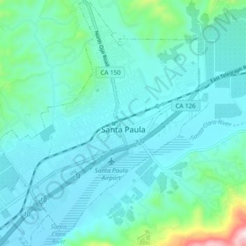
Name: Topografische Karte Santa Paula, Höhe, Relief.
Durchschnittliche Höhe: 148 m
Minimale Höhe: 62 m
Maximale Höhe: 682 m
Spenden
Rüste dich für dein nächstes Abenteuer:
Als Amazon-Partner verdient diese Website an qualifizierten Käufen, ohne zusätzliche Kosten für Sie.
Andere topografische Karten
Klicken Sie auf eine Karte, um ihre Topografie, ihre Höhe und ihr Relief anzuzeigen.
Mount Pinos
United States > California > Ventura County
During and immediately after heavy snow storms it may not be possible to drive to the top of Mount Pinos Road due to the lack of snow plow availability. In such cases it is common for the Kern County Roads Department to close a snow gate lower on the mountain. It is still possible to ski from the snow gate and…
Durchschnittliche Höhe: 2.468 m
Spenden
Rüste dich für dein nächstes Abenteuer:
Als Amazon-Partner verdient diese Website an qualifizierten Käufen, ohne zusätzliche Kosten für Sie.
Tradewinds Club
United States > California > Ventura County > Simi Valley
Durchschnittliche Höhe: 342 m
Spenden
Rüste dich für dein nächstes Abenteuer:
Als Amazon-Partner verdient diese Website an qualifizierten Käufen, ohne zusätzliche Kosten für Sie.
Lake Piru
United States > California > Ventura County
The elevation of the reservoir is 1,043 ft (318 m), and the elevation of the dam spillway is 1,055 ft (322 m). The dam is owned and operated by the United Water Conservation District based in nearby Santa Paula, California. The district is a multi-service district providing flood control, recreation services,…
Durchschnittliche Höhe: 375 m
Newbury Park
United States > California > Ventura County > Thousand Oaks > Newbury Park
Newbury Park can be described as a town, community, or section mostly within the Thousand Oaks city limits in addition to rural areas west of Thousand Oaks. Newbury Park is bordered by Lynn Road in the east and the Conejo Grade on the west. It borders the Santa Monica Mountains in the south, while Hill Canyon…
Durchschnittliche Höhe: 262 m
Spenden
Rüste dich für dein nächstes Abenteuer:
Als Amazon-Partner verdient diese Website an qualifizierten Käufen, ohne zusätzliche Kosten für Sie.
Jasmine Glen Estates
United States > California > Ventura County > Simi Valley
Durchschnittliche Höhe: 331 m
Spenden
Rüste dich für dein nächstes Abenteuer:
Als Amazon-Partner verdient diese Website an qualifizierten Käufen, ohne zusätzliche Kosten für Sie.
Johnson Creek Park
United States > California > Ventura County > Oxnard > Pleasant Valley Mobile Home Park
Durchschnittliche Höhe: 10 m
Casitas Springs
United States > California > Ventura County > Ventura > Casitas Springs
Durchschnittliche Höhe: 182 m
Greenwich Village
United States > California > Ventura County > Thousand Oaks > Greenwich Village
Durchschnittliche Höhe: 275 m
Spenden
Rüste dich für dein nächstes Abenteuer:
Als Amazon-Partner verdient diese Website an qualifizierten Käufen, ohne zusätzliche Kosten für Sie.