
Topografische Karte South Pittsburg
Interaktive Karte
Klicken Sie auf die Karte, um die Höhe anzuzeigen.
South Pittsburg
South Pittsburg is located at 35°0′30″N 85°42′38″W / 35.00833°N 85.71056°W / 35.00833; -85.71056 (35.008342, -85.710645). The city is situated in the southwestern Sequatchie Valley between the Cumberland Plateau on the west and the Tennessee River (Guntersville Lake) on the east. Two steep ridges— Whitacre Point on the north and Lodge Point on the south— extend outward from the Plateau to "wall in" the main portion of the city on the north, west, and south. The Richard City area lies opposite Lodge Point to the south, and the Battle Creek area lies opposite Whitacre Point to the north. At an elevation of approximately 630 ft (190 m), South Pittsburg is the lowest incorporated city in the East Tennessee Grand Division.
Über diese Karte
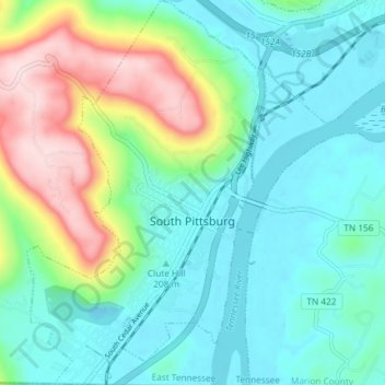
Name: Topografische Karte South Pittsburg, Höhe, Relief.
Durchschnittliche Höhe: 272 m
Minimale Höhe: 176 m
Maximale Höhe: 539 m
Andere topografische Karten
Klicken Sie auf eine Karte, um ihre Topografie, ihre Höhe und ihr Relief anzuzeigen.
Raulstontown
United States > Tennessee > Marion County > South Pittsburg
Durchschnittliche Höhe: 291 m