
Topografische Karte Town of Dresden
Interaktive Karte
Klicken Sie auf die Karte, um die Höhe anzuzeigen.
Über diese Karte
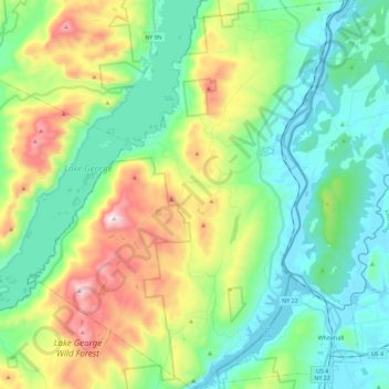
Name: Topografische Karte Town of Dresden, Höhe, Relief.
Ort: Town of Dresden, Washington County, New York, United States (43.53374 -73.57899 43.69923 -73.39372)
Durchschnittliche Höhe: 249 m
Minimale Höhe: 23 m
Maximale Höhe: 794 m
Andere topografische Karten
Klicken Sie auf eine Karte, um ihre Topografie, ihre Höhe und ihr Relief anzuzeigen.
Bald Mountain
United States > New York > Washington County
Bald Mountain, Washington County, New York, United States
Durchschnittliche Höhe: 261 m
Village of Cambridge
United States > New York > Washington County
Village of Cambridge, Town of White Creek, Washington County, New York, United States
Durchschnittliche Höhe: 165 m
Black Mountain
United States > New York > Washington County
Black Mountain, Town of Dresden, Washington County, New York, 12841, United States
Durchschnittliche Höhe: 487 m
West Hebron
United States > New York > Washington County > West Hebron
West Hebron, Town of Hebron, Washington County, New York, 12865, United States
Durchschnittliche Höhe: 209 m
Putnam Station
United States > New York > Washington County > Putnam Station
Putnam Station, Town of Putnam, Washington County, New York, United States
Durchschnittliche Höhe: 83 m
West Cambridge
United States > New York > Washington County > Town of Cambridge
West Cambridge, Town of Cambridge, Washington County, New York, United States
Durchschnittliche Höhe: 199 m
Village of Fort Edward
United States > New York > Washington County
Village of Fort Edward, Town of Fort Edward, Washington County, New York, United States
Durchschnittliche Höhe: 52 m