
Topografische Karte Union Mills
Interaktive Karte
Klicken Sie auf die Karte, um die Höhe anzuzeigen.
Über diese Karte
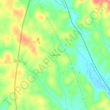
Name: Topografische Karte Union Mills, Höhe, Relief.
Durchschnittliche Höhe: 326 m
Minimale Höhe: 274 m
Maximale Höhe: 402 m
Andere topografische Karten
Klicken Sie auf eine Karte, um ihre Topografie, ihre Höhe und ihr Relief anzuzeigen.
Rutherfordton
United States > North Carolina > Rutherford County
Rutherfordton, Rutherford County, North Carolina, United States
Durchschnittliche Höhe: 302 m
Rutherfordton
United States > North Carolina > Rutherford County > Rutherfordton
Rutherfordton, Rutherford County, North Carolina, 28139, United States
Durchschnittliche Höhe: 300 m
Lake Lure
United States > North Carolina > Rutherford County
Lake Lure, Rutherford County, North Carolina, 28746, United States
Durchschnittliche Höhe: 363 m
Spindale
United States > North Carolina > Rutherford County > Spindale
Spindale, Rutherford County, North Carolina, 28160, United States
Durchschnittliche Höhe: 299 m
Chimney Rock
United States > North Carolina > Rutherford County > Chimney Rock
Chimney Rock, Rutherford County, North Carolina, 28720, United States
Durchschnittliche Höhe: 550 m