
Topografische Karte Big Sky
Interaktive Karte
Klicken Sie auf die Karte, um die Höhe anzuzeigen.
Über diese Karte
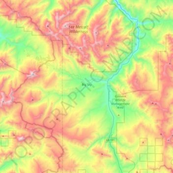
Name: Topografische Karte Big Sky, Höhe, Relief.
Ort: Big Sky, Gallatin County, Montana, United States (45.13076 -111.49439 45.37939 -111.03817)
Durchschnittliche Höhe: 2.435 m
Minimale Höhe: 1.689 m
Maximale Höhe: 3.382 m
This climatic region is typified by large seasonal temperature differences, with warm to hot summers and cold (sometimes severely cold) winters. According to the Köppen Climate Classification system, Big Sky has a borderline humid continental (Dfb) / alpine subarctic climate (Dfc). for most of the area, but the lower elevations may be closer to a dry continental climate.
Andere topografische Karten
Klicken Sie auf eine Karte, um ihre Topografie, ihre Höhe und ihr Relief anzuzeigen.
Bozeman
United States > Montana > Gallatin County
Bozeman, Gallatin County, Montana, United States
Durchschnittliche Höhe: 1.495 m
Belgrade
United States > Montana > Gallatin County
Belgrade, Gallatin County, Montana, 59714, United States
Durchschnittliche Höhe: 1.355 m
Lightning Lake
United States > Montana > Gallatin County
Lightning Lake, Gallatin County, Montana, United States
Durchschnittliche Höhe: 2.690 m
Bozeman
United States > Montana > Gallatin County > Bozeman
Bozeman, Gallatin County, Montana, 59715, United States
Durchschnittliche Höhe: 1.679 m
Springhill
United States > Montana > Gallatin County > Springhill
Springhill, Gallatin County, Montana, United States
Durchschnittliche Höhe: 1.491 m