
Topografische Karte Rocklin
Interaktive Karte
Klicken Sie auf die Karte, um die Höhe anzuzeigen.
Über diese Karte
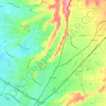
Name: Topografische Karte Rocklin, Höhe, Relief.
Ort: Rocklin, Placer County, California, United States (38.77032 -121.30001 38.85114 -121.18952)
Durchschnittliche Höhe: 95 m
Minimale Höhe: 36 m
Maximale Höhe: 200 m
Andere topografische Karten
Klicken Sie auf eine Karte, um ihre Topografie, ihre Höhe und ihr Relief anzuzeigen.
Roseville
United States > California > Placer County
Roseville, Placer County, California, United States
Durchschnittliche Höhe: 61 m
Devils Peak
United States > California > Placer County
Devils Peak, Placer County, California, United States
Durchschnittliche Höhe: 2.042 m
Auburn
United States > California > Placer County
Auburn, Placer County, California, 95603, United States
Durchschnittliche Höhe: 380 m
Lincoln
United States > California > Placer County > Lincoln
Lincoln, Placer County, California, United States
Durchschnittliche Höhe: 34 m
Kings Beach
United States > California > Placer County
Kings Beach, Placer County, California, 96143, United States
Durchschnittliche Höhe: 1.955 m