
Topografische Karte La Crosse
Interaktive Karte
Klicken Sie auf die Karte, um die Höhe anzuzeigen.
Über diese Karte
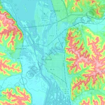
Name: Topografische Karte La Crosse, Höhe, Relief.
Ort: La Crosse, La Crosse County, Wisconsin, United States (43.74602 -91.27594 43.89838 -91.15709)
Durchschnittliche Höhe: 238 m
Minimale Höhe: 188 m
Maximale Höhe: 391 m
Surrounding the relatively flat prairie valley where La Crosse lies are towering 500-foot (150 m) bluffs, one of the most prominent of which is Grandad Bluff (mentioned in Life on the Mississippi by Mark Twain), which has an overlook of the three states region. This feature typifies the topography of the Driftless Area in which La Crosse sits. This rugged region is composed of high ridges dissected by narrow valleys called coulees, a French term. As a result, the area around La Crosse is frequently referred to as the "Coulee Region".
Andere topografische Karten
Klicken Sie auf eine Karte, um ihre Topografie, ihre Höhe und ihr Relief anzuzeigen.
North La Crosse
United States > Wisconsin > La Crosse County > La Crosse
North La Crosse, La Crosse, La Crosse County, Wisconsin, 54603, United States
Durchschnittliche Höhe: 197 m
Village of West Salem
United States > Wisconsin > La Crosse County > West Salem
Village of West Salem, West Salem, Town of Hamilton, La Crosse County, Wisconsin, United States
Durchschnittliche Höhe: 226 m
Madison Court
United States > Wisconsin > La Crosse County > La Crosse
Madison Court, La Crosse, La Crosse County, Wisconsin, United States
Durchschnittliche Höhe: 229 m
Onalaska
United States > Wisconsin > La Crosse County
Onalaska, La Crosse County, Wisconsin, United States
Durchschnittliche Höhe: 219 m