
Topografische Karte Arenas
Interaktive Karte
Klicken Sie auf die Karte, um die Höhe anzuzeigen.
Über diese Karte
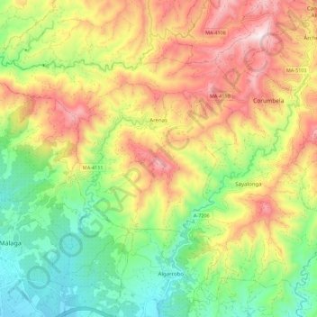
Name: Topografische Karte Arenas, Höhe, Relief.
Ort: Arenas, La Axarquía, Malaga, Andalusia, Spain (36.77277 -4.12733 36.83784 -4.01724)
Durchschnittliche Höhe: 353 m
Minimale Höhe: 18 m
Maximale Höhe: 772 m
Arenas's urban landscape is typically Andalusian with narrow streets, steep and with whitewashed buildings. It is surrounded by mountains very close to the Mediterranean Sea. Mount Bentomiz has an altitude of 711 m in altitude, steep slopes and with views over the coast and the region of Axarquia. Other mountains are Cerro Beas and Cerro Alto. Arenas shares with Canillas de Aceituno, Sedella, and Salares a large area in the Sierras of Tejeda, Almijara and Alhama Natural Park. Several trails, gorges, and streams allow for hiking and climbing.
Andere topografische Karten
Klicken Sie auf eine Karte, um ihre Topografie, ihre Höhe und ihr Relief anzuzeigen.
Riogordo
Spain > Andalusia > La Axarquía
Riogordo, La Axarquía, Malaga, Andalusia, 29180, Spain
Durchschnittliche Höhe: 595 m
Viñuela
Spain > Andalusia > La Axarquía
Viñuela, La Axarquía, Malaga, Andalusia, Spain
Durchschnittliche Höhe: 312 m
Arroyo
Spain > Andalusia > La Axarquía > Frigiliana
Arroyo, Frigiliana, La Axarquía, Malaga, Andalusia, 28788, Spain
Durchschnittliche Höhe: 559 m
Rincón de la Victoria
Spain > Andalusia > La Axarquía > Rincón de la Victoria
Rincón de la Victoria, La Axarquía, Malaga, Andalusia, Spain
Durchschnittliche Höhe: 168 m
Colmenar
Spain > Andalusia > La Axarquía > Colmenar
Colmenar, La Axarquía, Malaga, Andalusia, 29170, Spain
Durchschnittliche Höhe: 722 m
Comares
Spain > Andalusia > La Axarquía
Comares, La Axarquía, Malaga, Andalusia, 29195, Spain
Durchschnittliche Höhe: 355 m
Algarrobo
Spain > Andalusia > La Axarquía
Algarrobo, La Axarquía, Malaga, Andalusia, 29750, Spain
Durchschnittliche Höhe: 133 m
Nerja
Spain > Andalusia > La Axarquía
Nerja, La Axarquía, Malaga, Andalusia, Spain
Durchschnittliche Höhe: 485 m