
Topografische Karte Highland Park
Interaktive Karte
Klicken Sie auf die Karte, um die Höhe anzuzeigen.
Über diese Karte
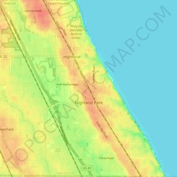
Name: Topografische Karte Highland Park, Höhe, Relief.
Ort: Highland Park, Lake County, Illinois, 60035, United States (42.15226 -87.85206 42.22225 -87.75885)
Durchschnittliche Höhe: 194 m
Minimale Höhe: 174 m
Maximale Höhe: 220 m
In 1867, ten men purchased Highland Park for $39,198.70. They were the original stockholders of the Highland Park Building Company. Following construction of the Chicago and Milwaukee Railroad, a depot was established at Highland Park and a plat, extending south to Central Avenue, was laid out in 1856. At that point, Highland Park was settled on mostly scattered farms and undeveloped forested land. Highland Park was established as a city on March 11, 1869, with a population of 500, and evolved from the two settlements of St. John and Port Clinton; St. John's Avenue and Port Clinton Square are named after the settlements. Highland Park was named from its parklike setting at a lofty elevation relative to the lake, and was given its name from Walter S. Gurnee. The town annexed the village of Ravinia in 1899.