
Topografische Karte Hawarden
Interaktive Karte
Klicken Sie auf die Karte, um die Höhe anzuzeigen.
Über diese Karte
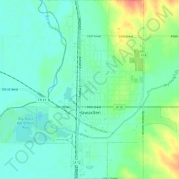
Name: Topografische Karte Hawarden, Höhe, Relief.
Ort: Hawarden, Sioux County, Iowa, United States (42.98198 -96.50035 43.01867 -96.46095)
Durchschnittliche Höhe: 365 m
Minimale Höhe: 348 m
Maximale Höhe: 406 m
Andere topografische Karten
Klicken Sie auf eine Karte, um ihre Topografie, ihre Höhe und ihr Relief anzuzeigen.
Sioux County
United States > Iowa > Sioux County
Sioux County, Iowa, United States
Durchschnittliche Höhe: 418 m
Chatsworth
United States > Iowa > Sioux County > Chatsworth > Chatsworth
Chatsworth, Sioux County, Iowa, 51011, United States
Durchschnittliche Höhe: 359 m
Chatsworth
United States > Iowa > Sioux County
Chatsworth, Sioux County, Iowa, 51011, United States
Durchschnittliche Höhe: 357 m