
Spenden
Rüste dich für dein nächstes Abenteuer:
Als Amazon-Partner verdient diese Website an qualifizierten Käufen, ohne zusätzliche Kosten für Sie.
Topografische Karte Ouistreham
Klicken Sie auf die Karte, um die Höhe anzuzeigen.
Spenden
Rüste dich für dein nächstes Abenteuer:
Als Amazon-Partner verdient diese Website an qualifizierten Käufen, ohne zusätzliche Kosten für Sie.
Ouistreham
Par contre, René Lepelley envisage, à la suite d'Auguste Longnon et de Louis Guinet, une étymologie par le vieil anglais westre « ouest », en se basant sur la régularité des formes Estreham ou Etreham attestées pour ce lieu jusqu'au XVIII siècle. À cela s'ajoute un argument topographique : ouest ne peut signifier qu'« à l'ouest de l'embouchure de l'Orne ». Longnon et Guinet ont proposé le vieux saxon westar de même sens, ce qui en ferait un toponyme plus ancien. Le vieil anglais westre « ouest » n'est pas mentionné par T. F. Hoad, mais le vieil anglais west semblable au vieux saxon west et Duden cite le moyen haut-allemand wester issu du vieux haut-allemand westar. Auguste Longnon a rapproché Ouistreham du nom de lieu anglais Westerham (Kent, Westarham 871 - 889, Oistreham 1086). Il convient sans doute de comparer l'élément Oistre- des formes anciennes, avec Oister- trouvé dans (Maisnillus) Oisterlandi attesté en 1059, aujourd'hui le Mesnil-Sterling au Tréport (Seine-Maritime) « Le village de l'ouest ». Ouistreham est située à l'ouest de l'embouchure de l'Orne, lieu marquant.
Spenden
Rüste dich für dein nächstes Abenteuer:
Als Amazon-Partner verdient diese Website an qualifizierten Käufen, ohne zusätzliche Kosten für Sie.
Über diese Karte
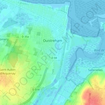
Name: Topografische Karte Ouistreham, Höhe, Relief.
Durchschnittliche Höhe: 12 m
Minimale Höhe: -5 m
Maximale Höhe: 55 m
Spenden
Rüste dich für dein nächstes Abenteuer:
Als Amazon-Partner verdient diese Website an qualifizierten Käufen, ohne zusätzliche Kosten für Sie.
Andere topografische Karten
Klicken Sie auf eine Karte, um ihre Topografie, ihre Höhe und ihr Relief anzuzeigen.
Colleville-Montgomery
France > Normandie > Calvados > Colleville-Montgomery > Colleville-Montgomery
Durchschnittliche Höhe: 20 m
Manoir de la Rivière
France > Normandie > Calvados > Sainte-Marguerite-d'Elle
Durchschnittliche Höhe: 68 m
Spenden
Rüste dich für dein nächstes Abenteuer:
Als Amazon-Partner verdient diese Website an qualifizierten Käufen, ohne zusätzliche Kosten für Sie.
Spenden
Rüste dich für dein nächstes Abenteuer:
Als Amazon-Partner verdient diese Website an qualifizierten Käufen, ohne zusätzliche Kosten für Sie.
Le Val de May
France > Normandie > Calvados > Saint-Martin-de-May > May-sur-Orne
Durchschnittliche Höhe: 49 m
Secqueville
France > Normandie > Calvados > Le Castelet > Garcelles-Secqueville
Durchschnittliche Höhe: 65 m
Spenden
Rüste dich für dein nächstes Abenteuer:
Als Amazon-Partner verdient diese Website an qualifizierten Käufen, ohne zusätzliche Kosten für Sie.
Spenden
Rüste dich für dein nächstes Abenteuer:
Als Amazon-Partner verdient diese Website an qualifizierten Käufen, ohne zusätzliche Kosten für Sie.
Spenden
Rüste dich für dein nächstes Abenteuer:
Als Amazon-Partner verdient diese Website an qualifizierten Käufen, ohne zusätzliche Kosten für Sie.
Le Moulin Pinel
France > Normandie > Calvados > Souleuvre-en-Bocage > Le Tourneur
Durchschnittliche Höhe: 169 m
Les Blanches Landes
France > Normandie > Calvados > Souleuvre-en-Bocage > Saint-Martin-des-Besaces
Durchschnittliche Höhe: 181 m
Spenden
Rüste dich für dein nächstes Abenteuer:
Als Amazon-Partner verdient diese Website an qualifizierten Käufen, ohne zusätzliche Kosten für Sie.
Spenden
Rüste dich für dein nächstes Abenteuer:
Als Amazon-Partner verdient diese Website an qualifizierten Käufen, ohne zusätzliche Kosten für Sie.
Spenden
Rüste dich für dein nächstes Abenteuer:
Als Amazon-Partner verdient diese Website an qualifizierten Käufen, ohne zusätzliche Kosten für Sie.
Spenden
Rüste dich für dein nächstes Abenteuer:
Als Amazon-Partner verdient diese Website an qualifizierten Käufen, ohne zusätzliche Kosten für Sie.
Hameau d'Aunay
France > Normandie > Calvados > Valdallière > Saint-Charles-de-Percy
Durchschnittliche Höhe: 163 m
Spenden
Rüste dich für dein nächstes Abenteuer:
Als Amazon-Partner verdient diese Website an qualifizierten Käufen, ohne zusätzliche Kosten für Sie.
Spenden
Rüste dich für dein nächstes Abenteuer:
Als Amazon-Partner verdient diese Website an qualifizierten Käufen, ohne zusätzliche Kosten für Sie.
Les Châtaigniers
France > Normandie > Calvados > Saint-Philbert-des-Champs
Durchschnittliche Höhe: 140 m
Spenden
Rüste dich für dein nächstes Abenteuer:
Als Amazon-Partner verdient diese Website an qualifizierten Käufen, ohne zusätzliche Kosten für Sie.
Les Monts d'Aunay
France > Normandie > Calvados > Les Monts d'Aunay > Les Monts d'Aunay
Durchschnittliche Höhe: 151 m
Saint-Aubin-d'Arquenay
France > Normandie > Calvados > Saint-Aubin-d'Arquenay > Saint-Aubin-d'Arquenay
Durchschnittliche Höhe: 23 m
Spenden
Rüste dich für dein nächstes Abenteuer:
Als Amazon-Partner verdient diese Website an qualifizierten Käufen, ohne zusätzliche Kosten für Sie.
Le Moulin Lévesque
France > Normandie > Calvados > Sainte-Marguerite-d'Elle
Durchschnittliche Höhe: 41 m
Crapouville
France > Normandie > Calvados > Condé-en-Normandie > Saint-Pierre-la-Vieille
Durchschnittliche Höhe: 226 m
Spenden
Rüste dich für dein nächstes Abenteuer:
Als Amazon-Partner verdient diese Website an qualifizierten Käufen, ohne zusätzliche Kosten für Sie.
Saint-Silly
France > Normandie > Calvados > Thury-Harcourt-le-Hom > Thury-Harcourt
Durchschnittliche Höhe: 91 m
Spenden
Rüste dich für dein nächstes Abenteuer:
Als Amazon-Partner verdient diese Website an qualifizierten Käufen, ohne zusätzliche Kosten für Sie.
Spenden
Rüste dich für dein nächstes Abenteuer:
Als Amazon-Partner verdient diese Website an qualifizierten Käufen, ohne zusätzliche Kosten für Sie.
Falaise des vaches noires
France > Normandie > Calvados > Houlgate > Fontaine Pannier
Durchschnittliche Höhe: 44 m
Spenden
Rüste dich für dein nächstes Abenteuer:
Als Amazon-Partner verdient diese Website an qualifizierten Käufen, ohne zusätzliche Kosten für Sie.
Spenden
Rüste dich für dein nächstes Abenteuer:
Als Amazon-Partner verdient diese Website an qualifizierten Käufen, ohne zusätzliche Kosten für Sie.
Spenden
Rüste dich für dein nächstes Abenteuer:
Als Amazon-Partner verdient diese Website an qualifizierten Käufen, ohne zusätzliche Kosten für Sie.
Le Moncel
France > Normandie > Calvados > Saint-Pierre-en-Auge > Vaudeloges
Durchschnittliche Höhe: 86 m
Spenden
Rüste dich für dein nächstes Abenteuer:
Als Amazon-Partner verdient diese Website an qualifizierten Käufen, ohne zusätzliche Kosten für Sie.
Spenden
Rüste dich für dein nächstes Abenteuer:
Als Amazon-Partner verdient diese Website an qualifizierten Käufen, ohne zusätzliche Kosten für Sie.
Quartier de l'Église
France > Normandie > Calvados > Livarot-Pays-d'Auge > Le Mesnil-Bacley
Durchschnittliche Höhe: 124 m
Spenden
Rüste dich für dein nächstes Abenteuer:
Als Amazon-Partner verdient diese Website an qualifizierten Käufen, ohne zusätzliche Kosten für Sie.
Spenden
Rüste dich für dein nächstes Abenteuer:
Als Amazon-Partner verdient diese Website an qualifizierten Käufen, ohne zusätzliche Kosten für Sie.
La Boudehannière
France > Normandie > Calvados > Dialan sur Chaîne > Jurques
Durchschnittliche Höhe: 210 m
Spenden
Rüste dich für dein nächstes Abenteuer:
Als Amazon-Partner verdient diese Website an qualifizierten Käufen, ohne zusätzliche Kosten für Sie.
Manoir de la Morsanglière
France > Normandie > Calvados > Bonneville-la-Louvet
Durchschnittliche Höhe: 81 m
Spenden
Rüste dich für dein nächstes Abenteuer:
Als Amazon-Partner verdient diese Website an qualifizierten Käufen, ohne zusätzliche Kosten für Sie.