
Topografische Karte Alamogordo
Interaktive Karte
Klicken Sie auf die Karte, um die Höhe anzuzeigen.
Über diese Karte
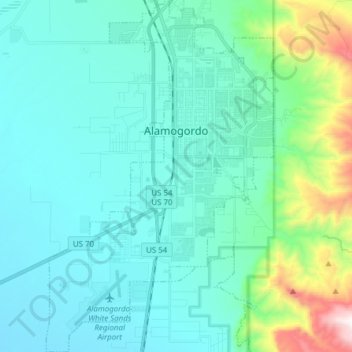
Name: Topografische Karte Alamogordo, Höhe, Relief.
Ort: Alamogordo, Otero County, New Mexico, United States (32.81874 -106.01686 32.94756 -105.91772)
Durchschnittliche Höhe: 1.515 m
Minimale Höhe: 1.248 m
Maximale Höhe: 2.467 m
As of 2010, Alamogordo had a total area of 19.3 square miles (50.0 km2), all of it land. The city is located at an elevation of 4,336 feet (1,322 m) on the western flank of the Sacramento Mountains and on the eastern edge of the Tularosa Basin. It lies within the Rio Grande rift and in the northernmost part of the Chihuahuan Desert.:36 Tectonic activity is low in the Tularosa Basin. Plants native to the area are typical of the southern New Mexico foothills and include creosote bush, mesquite, saltbush, cottonwood, desert willow, and many species of cactus and yucca.
Andere topografische Karten
Klicken Sie auf eine Karte, um ihre Topografie, ihre Höhe und ihr Relief anzuzeigen.
Cloudcroft
United States > New Mexico > Otero County
Cloudcroft, Otero County, New Mexico, United States
Durchschnittliche Höhe: 2.643 m
Alamorosa
United States > New Mexico > Otero County
Alamorosa, Otero County, New Mexico, 88337, United States
Durchschnittliche Höhe: 1.365 m
La Luz
United States > New Mexico > Otero County
La Luz, Otero County, New Mexico, 88337, United States
Durchschnittliche Höhe: 1.452 m
Orogrande
United States > New Mexico > Otero County
Orogrande, Otero County, New Mexico, 88342, United States
Durchschnittliche Höhe: 1.285 m
Weed
United States > New Mexico > Otero County
Weed, Otero County, New Mexico, 88354, United States
Durchschnittliche Höhe: 2.212 m
Timberon
United States > New Mexico > Otero County
Timberon, Otero County, New Mexico, 88350, United States
Durchschnittliche Höhe: 2.181 m
Apache
United States > New Mexico > Otero County
Apache, Otero County, New Mexico, United States
Durchschnittliche Höhe: 1.957 m
Cloudcroft
United States > New Mexico > Otero County > Cloudcroft
Cloudcroft, Otero County, New Mexico, 88317, United States
Durchschnittliche Höhe: 2.636 m
White Sands National Park
United States > New Mexico > Otero County
White Sands National Park, Otero County, New Mexico, United States
Durchschnittliche Höhe: 1.214 m
Alamogordo
United States > New Mexico > Otero County
Alamogordo, Otero County, New Mexico, 88310, United States
Durchschnittliche Höhe: 1.644 m
La Luz
United States > New Mexico > Otero County
La Luz, Otero County, New Mexico, 88337, United States
Durchschnittliche Höhe: 1.493 m
High Rolls
United States > New Mexico > Otero County
High Rolls, Otero County, New Mexico, 88325, United States
Durchschnittliche Höhe: 2.036 m
Mayhill
United States > New Mexico > Otero County
Mayhill, Otero County, New Mexico, United States
Durchschnittliche Höhe: 2.104 m
Sacramento
United States > New Mexico > Otero County
Sacramento, Otero County, New Mexico, 88347, United States
Durchschnittliche Höhe: 2.320 m