
Topografische Karte Pereira
Interaktive Karte
Klicken Sie auf die Karte, um die Höhe anzuzeigen.
Über diese Karte
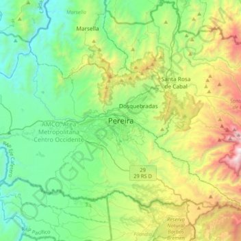
Name: Topografische Karte Pereira, Höhe, Relief.
Durchschnittliche Höhe: 1.564 m
Minimale Höhe: 859 m
Maximale Höhe: 3.365 m
Pereira is located on the central mountain range, on the Otún river valley, and part of the Cauca river valley. Pereira, like many Colombian cities, has high-elevation areas with difficult access or flat or steep parts. The streets are laid out according to the elevation of the respective zones.
Andere topografische Karten
Klicken Sie auf eine Karte, um ihre Topografie, ihre Höhe und ihr Relief anzuzeigen.
El Calvario
Colombia > Risaralda > Pereira
El Calvario, Pereira, Risaralda, 66002, Colombia
Durchschnittliche Höhe: 1.493 m