
Topografische Karte Port Nolloth
Interaktive Karte
Klicken Sie auf die Karte, um die Höhe anzuzeigen.
Über diese Karte
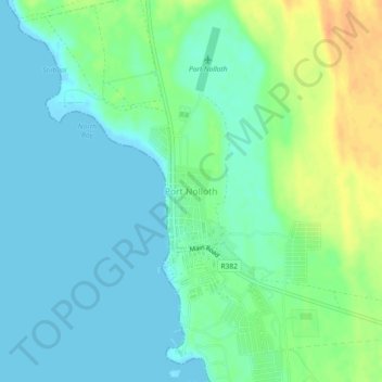
Name: Topografische Karte Port Nolloth, Höhe, Relief.
Durchschnittliche Höhe: 12 m
Minimale Höhe: -3 m
Maximale Höhe: 39 m
Andere topografische Karten
Klicken Sie auf eine Karte, um ihre Topografie, ihre Höhe und ihr Relief anzuzeigen.
Richtersveld Ward 3
South Africa > Northern Cape > Namakwa District Municipality > Richtersveld Local Municipality
Richtersveld Ward 3, Richtersveld Local Municipality, Namakwa District Municipality, Northern Cape, South Africa
Durchschnittliche Höhe: 289 m
Alexander Bay
South Africa > Northern Cape > Namakwa District Municipality > Richtersveld Local Municipality
Alexander Bay, Richtersveld Local Municipality, Namakwa District Municipality, Northern Cape, South Africa
Durchschnittliche Höhe: 15 m