
Topografische Karte Wejherowo
Interaktive Karte
Klicken Sie auf die Karte, um die Höhe anzuzeigen.
Über diese Karte
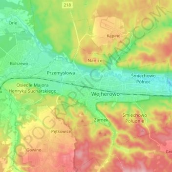
Name: Topografische Karte Wejherowo, Höhe, Relief.
Ort: Wejherowo, Wejherowo County, Pomeranian Voivodeship, Poland (54.57808 18.16262 54.63410 18.30463)
Durchschnittliche Höhe: 71 m
Minimale Höhe: 5 m
Maximale Höhe: 158 m
Wejherowo is located in Pomeralia, in the ethnocultural region of Kashubia, approximately 11 km (7 mi) west of the town of Rumia, 32 kilometres (20 miles) east of the town of Lębork and 35 km (22 mi) north-west of the regional metropole of Gdańsk, in the broad glacial valley of the river Rheda at an altitude of 30 metres (98 feet) above sea level.