
Topografische Karte Richmond
Interaktive Karte
Klicken Sie auf die Karte, um die Höhe anzuzeigen.
Über diese Karte
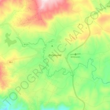
Name: Topografische Karte Richmond, Höhe, Relief.
Durchschnittliche Höhe: 907 m
Minimale Höhe: 686 m
Maximale Höhe: 1.211 m
Andere topografische Karten
Klicken Sie auf eine Karte, um ihre Topografie, ihre Höhe und ihr Relief anzuzeigen.
Richmond Local Municipality
South Africa > KwaZulu-Natal > uMgungundlovu District Municipality > Richmond Local Municipality
Richmond Local Municipality, uMgungundlovu District Municipality, KwaZulu-Natal, South Africa
Durchschnittliche Höhe: 837 m