
Topografische Karte Town of Bolton
Interaktive Karte
Klicken Sie auf die Karte, um die Höhe anzuzeigen.
Über diese Karte
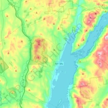
Name: Topografische Karte Town of Bolton, Höhe, Relief.
Ort: Town of Bolton, Warren County, New York, United States (43.44207 -73.75035 43.67838 -73.52540)
Durchschnittliche Höhe: 297 m
Minimale Höhe: 80 m
Maximale Höhe: 791 m
Andere topografische Karten
Klicken Sie auf eine Karte, um ihre Topografie, ihre Höhe und ihr Relief anzuzeigen.
Silver Bay
United States > New York > Warren County
Silver Bay, Town of Hague, Warren County, New York, 12874, United States
Durchschnittliche Höhe: 218 m
Height of Land Mountain
United States > New York > Warren County > Town of Johnsburg
Height of Land Mountain, Town of Johnsburg, Warren County, New York, United States
Durchschnittliche Höhe: 759 m
Burnt Pond
United States > New York > Warren County
Burnt Pond, Town of Horicon, Warren County, New York, United States
Durchschnittliche Höhe: 324 m
Diamond Point (hamlet)
United States > New York > Warren County > Town of Lake George
Diamond Point (hamlet), Town of Lake George, Warren County, New York, 12824, United States
Durchschnittliche Höhe: 191 m
Lake George
United States > New York > Warren County > Town of Bolton
Lake George, Town of Bolton, Warren County, New York, United States
Durchschnittliche Höhe: 247 m