
Spenden
Rüste dich für dein nächstes Abenteuer:
Als Amazon-Partner verdient diese Website an qualifizierten Käufen, ohne zusätzliche Kosten für Sie.
Topografische Karte Shafton Two Gates
Klicken Sie auf die Karte, um die Höhe anzuzeigen.
Spenden
Rüste dich für dein nächstes Abenteuer:
Als Amazon-Partner verdient diese Website an qualifizierten Käufen, ohne zusätzliche Kosten für Sie.
Shafton Two Gates
Shafton lies to the north of Shafton Two Gates, on the road to Ryhill. It is located at approximately 53° 35' 10" North, 1° 24' West, at an elevation of around 262 feet (80 m) above sea level. Sceptun in the Domesday Book of 1086 then later in c. 1160 Scaftona meaning a farmstead marked by a pole, or made with poles.
Spenden
Rüste dich für dein nächstes Abenteuer:
Als Amazon-Partner verdient diese Website an qualifizierten Käufen, ohne zusätzliche Kosten für Sie.
Über diese Karte
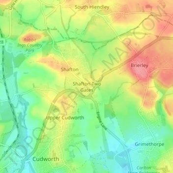
Name: Topografische Karte Shafton Two Gates, Höhe, Relief.
Durchschnittliche Höhe: 68 m
Minimale Höhe: 34 m
Maximale Höhe: 111 m
Spenden
Rüste dich für dein nächstes Abenteuer:
Als Amazon-Partner verdient diese Website an qualifizierten Käufen, ohne zusätzliche Kosten für Sie.
Andere topografische Karten
Klicken Sie auf eine Karte, um ihre Topografie, ihre Höhe und ihr Relief anzuzeigen.
Spenden
Rüste dich für dein nächstes Abenteuer:
Als Amazon-Partner verdient diese Website an qualifizierten Käufen, ohne zusätzliche Kosten für Sie.
Shafton
United Kingdom > England > Barnsley
Shafton lies to the north of Shafton Two Gates, on the road to Ryhill. It is located at approximately 53° 35' 10" North, 1° 24' West, at an elevation of around 262 feet (80 m) above sea level. Sceptun in the Domesday Book of 1086 then later in c. 1160 Scaftona meaning a farmstead marked by a pole, or made…
Durchschnittliche Höhe: 65 m
High Hoyland
United Kingdom > England > Barnsley
High Hoyland is a village and civil parish in the Metropolitan Borough of Barnsley in South Yorkshire, England, on the border with West Yorkshire. It lies to the west of Kexbrough, and is located at approximately 53°35′10″N 1°35′30″W / 53.58611°N 1.59167°W / 53.58611; -1.59167, at an…
Durchschnittliche Höhe: 139 m
Spenden
Rüste dich für dein nächstes Abenteuer:
Als Amazon-Partner verdient diese Website an qualifizierten Käufen, ohne zusätzliche Kosten für Sie.