
Topografische Karte Donnelly
Interaktive Karte
Klicken Sie auf die Karte, um die Höhe anzuzeigen.
Über diese Karte
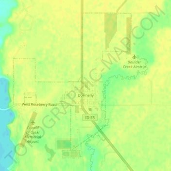
Name: Topografische Karte Donnelly, Höhe, Relief.
Ort: Donnelly, Valley County, Idaho, United States (44.72257 -116.09364 44.74549 -116.06739)
Durchschnittliche Höhe: 1.483 m
Minimale Höhe: 1.469 m
Maximale Höhe: 1.488 m
Donnelly is located at 44°43′49″N 116°4′37″W / 44.73028°N 116.07694°W / 44.73028; -116.07694, at an elevation of 4,865 feet (1,483 m) above sea level. According to the United States Census Bureau, the city has a total area of 0.45 square miles (1.17 km2), all of it land.
Andere topografische Karten
Klicken Sie auf eine Karte, um ihre Topografie, ihre Höhe und ihr Relief anzuzeigen.
Cascade
United States > Idaho > Valley County
Cascade, Valley County, Idaho, 83611, United States
Durchschnittliche Höhe: 1.478 m
McCall
United States > Idaho > Valley County
McCall, Valley County, Idaho, 83638, United States
Durchschnittliche Höhe: 1.546 m