
Topografische Karte Guamal
Interaktive Karte
Klicken Sie auf die Karte, um die Höhe anzuzeigen.
Über diese Karte
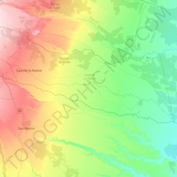
Name: Topografische Karte Guamal, Höhe, Relief.
Ort: Guamal, Meta, Colombia (3.70952 -73.76368 3.86257 -73.35698)
Durchschnittliche Höhe: 342 m
Minimale Höhe: 232 m
Maximale Höhe: 534 m
Andere topografische Karten
Klicken Sie auf eine Karte, um ihre Topografie, ihre Höhe und ihr Relief anzuzeigen.
Vanguardia
Colombia > Meta > Villavicencio
Vanguardia, Villavicencio, Meta, 500010, Colombia
Durchschnittliche Höhe: 455 m
Villavicencio
Villavicencio, Capital, Meta, RAP (Especial) Central, Colombia
Durchschnittliche Höhe: 471 m
Salinas de Upin
Colombia > Meta > Restrepo > Restrepo
Salinas de Upin, Restrepo, Piedemonte, Meta, Colombia
Durchschnittliche Höhe: 721 m
El Castillo
Colombia > Meta > El Castillo
El Castillo, Ariari, Meta, Colombia
Durchschnittliche Höhe: 895 m
Villavicencio
Colombia > Meta > Villavicencio
Villavicencio, Capital, Meta, Orinoquia, Colombia
Durchschnittliche Höhe: 870 m
Samarcanda
Colombia > Meta > San Luis de Cubarral
Samarcanda, San Luis de Cubarral, Meta, Colombia
Durchschnittliche Höhe: 540 m