
Spenden
Rüste dich für dein nächstes Abenteuer:
Als Amazon-Partner verdient diese Website an qualifizierten Käufen, ohne zusätzliche Kosten für Sie.
Topografische Karte Tulsa
Klicken Sie auf die Karte, um die Höhe anzuzeigen.
Spenden
Rüste dich für dein nächstes Abenteuer:
Als Amazon-Partner verdient diese Website an qualifizierten Käufen, ohne zusätzliche Kosten für Sie.
Tulsa
Tulsa, located in northeastern Oklahoma, is characterized by a diverse and rolling topography that marks its transition from the Great Plains to the Ozark foothills. The city's elevation averages around 700 feet (approximately 210 meters) above sea level, with some areas reaching heights of up to 1,050 feet (320 meters). This region, part of the ecoregion known as "Green Country," features a mix of forests and grasslands, supported by a relatively moist climate compared to other parts of Oklahoma. The landscape is punctuated by numerous lakes and rivers, adding to its scenic beauty and ecological variety. This combination of terrain provides a unique backdrop for the city, contributing to its reputation as one of the most topographically varied areas in the state.
Spenden
Rüste dich für dein nächstes Abenteuer:
Als Amazon-Partner verdient diese Website an qualifizierten Käufen, ohne zusätzliche Kosten für Sie.
Über diese Karte
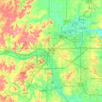
Name: Topografische Karte Tulsa, Höhe, Relief.
Ort: Tulsa, Oklahoma, United States (35.96830 -96.07448 36.33666 -95.68160)
Durchschnittliche Höhe: 221 m
Minimale Höhe: 166 m
Maximale Höhe: 321 m
Spenden
Rüste dich für dein nächstes Abenteuer:
Als Amazon-Partner verdient diese Website an qualifizierten Käufen, ohne zusätzliche Kosten für Sie.
Andere topografische Karten
Klicken Sie auf eine Karte, um ihre Topografie, ihre Höhe und ihr Relief anzuzeigen.