
Topografische Karte Gurdaspur
Interaktive Karte
Klicken Sie auf die Karte, um die Höhe anzuzeigen.
Gurdaspur
All the Tehsils of the district namely Gurdaspur, Batala and Dera Baba Nanak are plain and similar to the rest of the Punjab plains in structure. The landscape of the district has varied topography comprising undulating plan, the flood plains of the Ravi and the Beas and the upland plain.
Über diese Karte
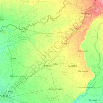
Name: Topografische Karte Gurdaspur, Höhe, Relief.
Ort: Gurdaspur, Punjab, India (31.59387 74.88848 32.21387 75.60134)
Durchschnittliche Höhe: 247 m
Minimale Höhe: 225 m
Maximale Höhe: 294 m
Andere topografische Karten
Klicken Sie auf eine Karte, um ihre Topografie, ihre Höhe und ihr Relief anzuzeigen.
Amritsar
India > Punjab > Amritsar I Tahsil
Amritsar is located at 31°38′N 74°52′E / 31.63°N 74.87°E / 31.63; 74.87 with an average elevation of 234 metres (768 ft) in the Majha region of the state of Punjab in North India and lies about 15 miles (24 km) east of the border with Pakistan. Administrative towns includes Ajnala, Attari,…
Durchschnittliche Höhe: 231 m
Ludhiana
India > Punjab > Ludhiana (West) Tahsil
Ludhiana is located at 30°54′N 75°51′E / 30.9°N 75.85°E / 30.9; 75.85. It has an average elevation of 244 metres (801 ft). Ludhiana City, to its residents, consists of the Old City and the New City. The new city primarily consists of the Civil Lines area which was historically known as the…
Durchschnittliche Höhe: 247 m