
Topografische Karte North and Middle Andaman
Interaktive Karte
Klicken Sie auf die Karte, um die Höhe anzuzeigen.
Über diese Karte
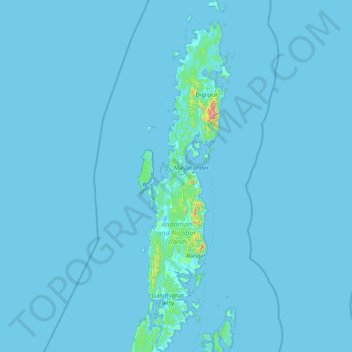
Name: Topografische Karte North and Middle Andaman, Höhe, Relief.
Durchschnittliche Höhe: 4 m
Minimale Höhe: -2 m
Maximale Höhe: 682 m
Andere topografische Karten
Klicken Sie auf eine Karte, um ihre Topografie, ihre Höhe und ihr Relief anzuzeigen.
Car Nicobar
India > Andaman and Nicobar Islands
Car Nicobar, Nicobar District, Andaman and Nicobar Islands, India
Durchschnittliche Höhe: 11 m
Nicobar Islands
India > Andaman and Nicobar Islands > Great Nicobar
Nicobar Islands, Great Nicobar, Nicobar, Andaman and Nicobar Islands, India
Durchschnittliche Höhe: 2 m
Port Blair
India > Andaman and Nicobar Islands > Port Blair
Port Blair, Andaman and Nicobar Islands, 744101, India
Durchschnittliche Höhe: 14 m
Great Channel
India > Andaman and Nicobar Islands
Great Channel, Andaman and Nicobar Islands, India
Durchschnittliche Höhe: 0 m
South Andaman
India > Andaman and Nicobar Islands
South Andaman, Andaman and Nicobar Islands, India
Durchschnittliche Höhe: 3 m