
Topografische Karte Bengaluru
Interaktive Karte
Klicken Sie auf die Karte, um die Höhe anzuzeigen.
Über diese Karte
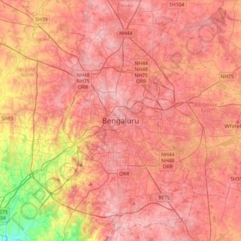
Name: Topografische Karte Bengaluru, Höhe, Relief.
Durchschnittliche Höhe: 879 m
Minimale Höhe: 712 m
Maximale Höhe: 968 m
Bangalore (/bæŋɡəˈlɔːr/), officially known as Bengaluru (Kannada pronunciation: (listen)), is the capital and the largest city of the Indian state of Karnataka. It has a population of more than 8 million and a metropolitan population of around 11 million, making it the third most populous city and fifth most populous urban agglomeration in India. Located in southern India on the Deccan Plateau, at a height of over 900 m (3,000 ft) above sea level, Bangalore is known for its pleasant climate throughout the year. Its elevation is the highest among the major cities of India.