
Topografische Karte Dylewska Góra
Interaktive Karte
Klicken Sie auf die Karte, um die Höhe anzuzeigen.
Dylewska Góra
Dylewska Góra (German: Kernsdorfer Höhe) is a hill located in northeastern Poland, south of the town of Ostróda, in the Warmian-Masurian Voivodeship. With elevation of 312 metres above sea level, it is one of the highest points of northern and central Poland. Dylewska Góra is a morainic hill, with its eastern and northern slopes covered by beech forest. On top there is a TV tower, as well as a 37-metre-high observation tower, which provides views of area up to 50 kilometres away.
Über diese Karte
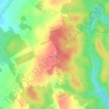
Name: Topografische Karte Dylewska Góra, Höhe, Relief.
Durchschnittliche Höhe: 269 m
Minimale Höhe: 227 m
Maximale Höhe: 311 m