
Topografische Karte Village-Neuf
Interaktive Karte
Klicken Sie auf die Karte, um die Höhe anzuzeigen.
Über diese Karte
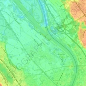
Name: Topografische Karte Village-Neuf, Höhe, Relief.
Durchschnittliche Höhe: 248 m
Minimale Höhe: 232 m
Maximale Höhe: 272 m
Andere topografische Karten
Klicken Sie auf eine Karte, um ihre Topografie, ihre Höhe und ihr Relief anzuzeigen.
Pulvermuehle
France > Grand Est > Haut-Rhin > Volgelsheim
Pulvermuehle, Volgelsheim, Colmar-Ribeauvillé, Haut-Rhin, Grand Est, France métropolitaine, 68600, France
Durchschnittliche Höhe: 192 m
Les Basses Huttes
France > Grand Est > Haut-Rhin > Orbey
Les Basses Huttes, Orbey, Colmar-Ribeauvillé, Haut-Rhin, Grand Est, France métropolitaine, 68370, France
Durchschnittliche Höhe: 809 m
Kaysersberg
France > Grand Est > Haut-Rhin > Kaysersberg-Vignoble
Kaysersberg, Kaysersberg-Vignoble, Colmar-Ribeauvillé, Haut-Rhin, Grand Est, France métropolitaine, 68240, France
Durchschnittliche Höhe: 523 m
Michelbach
France > Grand Est > Haut-Rhin > Aspach-Michelbach
Michelbach, Aspach-Michelbach, Thann-Guebwiller, Haut-Rhin, Grand Est, France métropolitaine, 68700, France
Durchschnittliche Höhe: 338 m